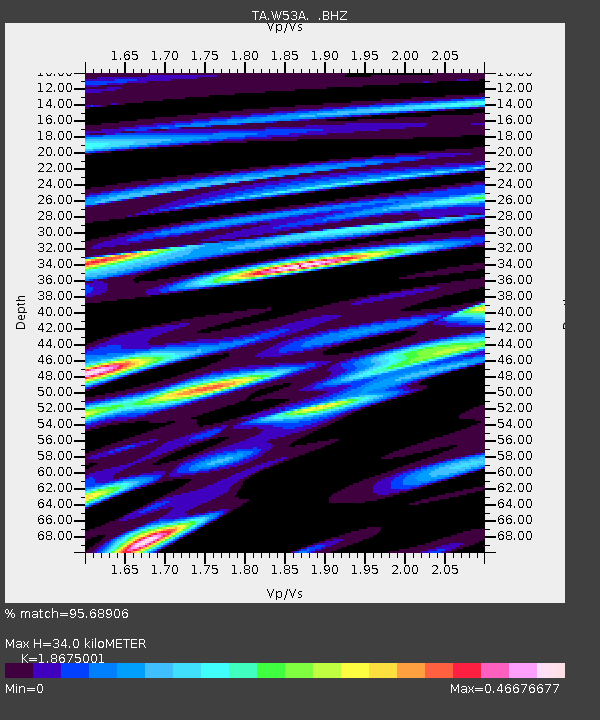
W53A Cullowhee, NC, USA - Earthquake Result Viewer
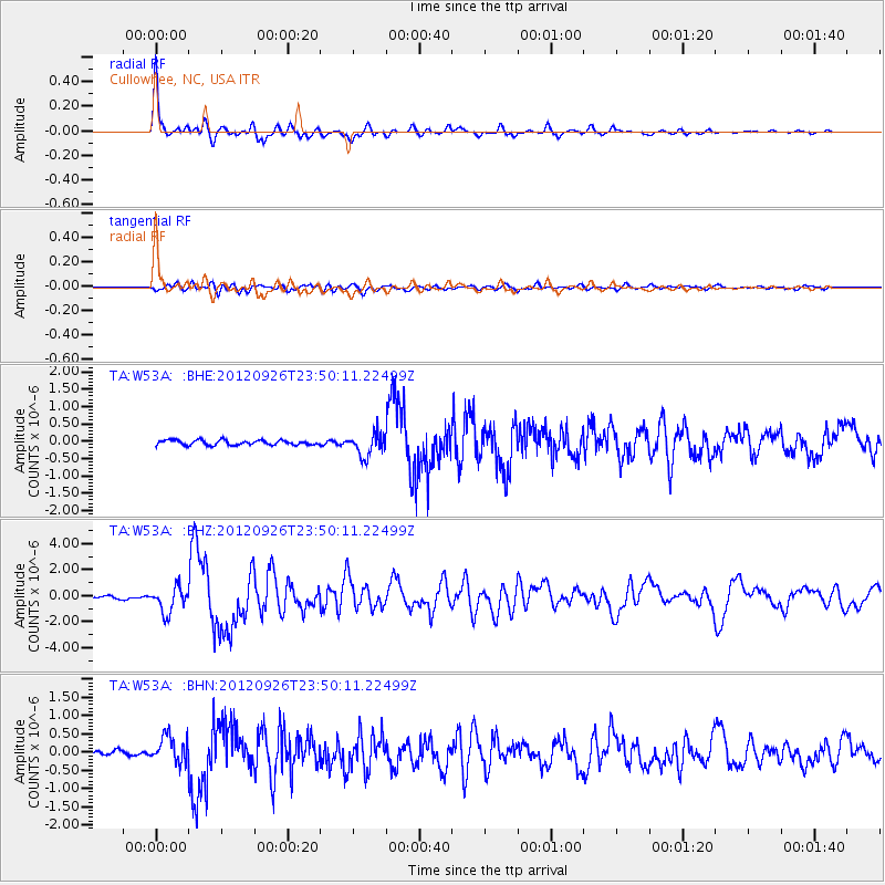
Earthquake location: Andreanof Islands, Aleutian Is.
Earthquake latitude/longitude: 51.6/-178.3
Earthquake time(UTC): 2012/09/26 (270) 23:39:55 GMT
Earthquake Depth: 16 km
Earthquake Magnitude: 6.3 MB, 6.5 MS, 6.4 MW, 6.4 MW
Earthquake Catalog/Contributor: WHDF/NEIC
Network: TA USArray Transportable Network (new EarthScope stations)
Station: W53A Cullowhee, NC, USA
Lat/Lon: 35.17 N/83.16 W
Elevation: 1180 m
Distance: 66.3 deg
Az: 63.044 deg
Baz: 317.257 deg
Ray Param: 0.0577145
Estimated Moho Depth: 34.0 km
Estimated Crust Vp/Vs: 1.87
Assumed Crust Vp: 6.35 km/s
Estimated Crust Vs: 3.4 km/s
Estimated Crust Poisson's Ratio: 0.30
Radial Match: 95.68906 %
Radial Bump: 400
Transverse Match: 79.42861 %
Transverse Bump: 400
SOD ConfigId: 478790
Insert Time: 2013-02-22 23:48:12.476 +0000
GWidth: 2.5
Max Bumps: 400
Tol: 0.001

Signal To Noise

ChannelStoNSTALTA
TA:W53A: :BHZ:20120926T23:50:11.22499Z11.56073959.686092E-78.378437E-8
TA:W53A: :BHN:20120926T23:50:11.22499Z6.2473743.619931E-75.7943243E-8
TA:W53A: :BHE:20120926T23:50:11.22499Z4.62133843.2651178E-77.065308E-8
Arrivals
Ps4.8 SECOND
PpPs15 SECOND
PsPs/PpSs20 SECOND