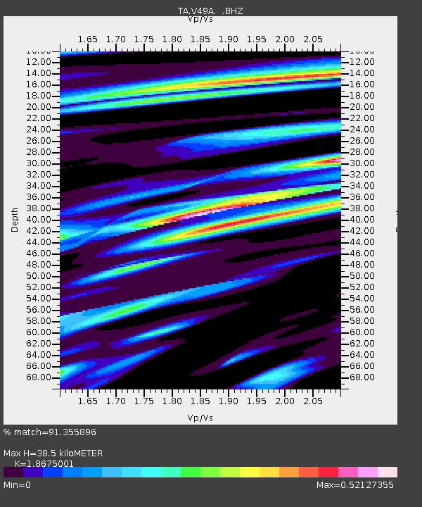
V49A McMinnville, TN, USA - Earthquake Result Viewer
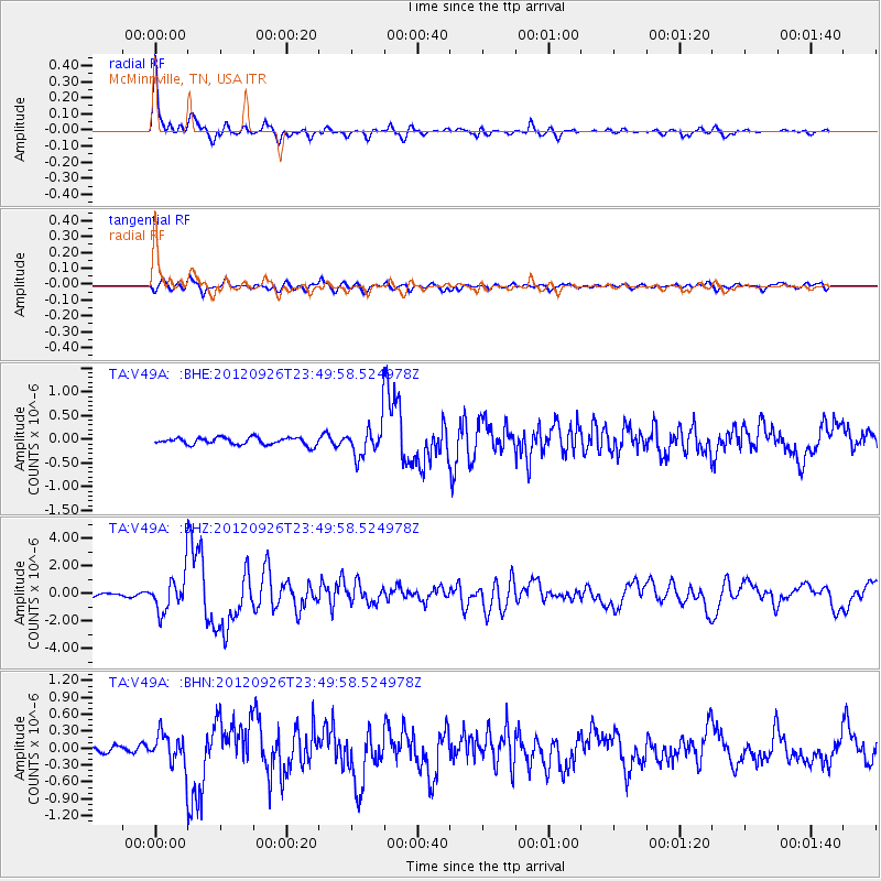
Earthquake location: Andreanof Islands, Aleutian Is.
Earthquake latitude/longitude: 51.6/-178.3
Earthquake time(UTC): 2012/09/26 (270) 23:39:55 GMT
Earthquake Depth: 16 km
Earthquake Magnitude: 6.3 MB, 6.5 MS, 6.4 MW, 6.4 MW
Earthquake Catalog/Contributor: WHDF/NEIC
Network: TA USArray Transportable Network (new EarthScope stations)
Station: V49A McMinnville, TN, USA
Lat/Lon: 35.77 N/85.90 W
Elevation: 329 m
Distance: 64.3 deg
Az: 64.388 deg
Baz: 316.236 deg
Ray Param: 0.058995947
Estimated Moho Depth: 38.5 km
Estimated Crust Vp/Vs: 1.87
Assumed Crust Vp: 6.35 km/s
Estimated Crust Vs: 3.4 km/s
Estimated Crust Poisson's Ratio: 0.30
Radial Match: 91.355896 %
Radial Bump: 360
Transverse Match: 83.47943 %
Transverse Bump: 400
SOD ConfigId: 478790
Insert Time: 2013-02-22 23:48:38.481 +0000
GWidth: 2.5
Max Bumps: 400
Tol: 0.001

Signal To Noise

ChannelStoNSTALTA
TA:V49A: :BHZ:20120926T23:49:58.524978Z14.4000481.2980406E-69.014141E-8
TA:V49A: :BHN:20120926T23:49:58.524978Z3.93407772.6971543E-76.855875E-8
TA:V49A: :BHE:20120926T23:49:58.524978Z4.62226873.48781E-77.545666E-8
Arrivals
Ps5.5 SECOND
PpPs17 SECOND
PsPs/PpSs22 SECOND