You are here: Home > Network List > TA - USArray Transportable Network (new EarthScope stations) Stations List
> Station R56A Bull Pasture Mountain, McDowell, VA, USA > Earthquake Result Viewer
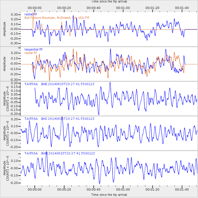
R56A Bull Pasture Mountain, McDowell, VA, USA - Earthquake Result Viewer
*The percent match for this event was below the threshold and hence no stack was calculated.
| Earthquake location: |
Near East Coast Of Honshu, Japan |
| Earthquake latitude/longitude: |
37.1/141.1 |
| Earthquake time(UTC): |
2014/06/15 (166) 20:14:50 GMT |
| Earthquake Depth: |
40 km |
| Earthquake Magnitude: |
5.6 MB |
| Earthquake Catalog/Contributor: |
NEIC PDE/NEIC COMCAT |
|
| Network: |
TA USArray Transportable Network (new EarthScope stations) |
| Station: |
R56A Bull Pasture Mountain, McDowell, VA, USA |
| Lat/Lon: |
38.41 N/79.40 W |
| Elevation: |
902 m |
|
| Distance: |
96.1 deg |
| Az: |
30.859 deg |
| Baz: |
328.539 deg |
| Ray Param: |
$rayparam |
*The percent match for this event was below the threshold and hence was not used in the summary stack. |
|
| Radial Match: |
43.29734 % |
| Radial Bump: |
400 |
| Transverse Match: |
59.774937 % |
| Transverse Bump: |
400 |
| SOD ConfigId: |
3390531 |
| Insert Time: |
2019-04-12 07:03:05.132 +0000 |
| GWidth: |
2.5 |
| Max Bumps: |
400 |
| Tol: |
0.001 |
|
Signal To Noise
| Channel | StoN | STA | LTA |
| TA:R56A: :BHZ:20140615T20:27:41.550012Z | 1.2803627 | 8.4466514E-8 | 6.597077E-8 |
| TA:R56A: :BHN:20140615T20:27:41.550012Z | 1.3430887 | 9.668236E-8 | 7.1985085E-8 |
| TA:R56A: :BHE:20140615T20:27:41.550012Z | 0.76878536 | 4.7449397E-8 | 6.171996E-8 |
| Arrivals |
| Ps | |
| PpPs | |
| PsPs/PpSs | |


