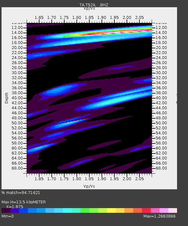
T52A Hallie, KY, USA - Earthquake Result Viewer
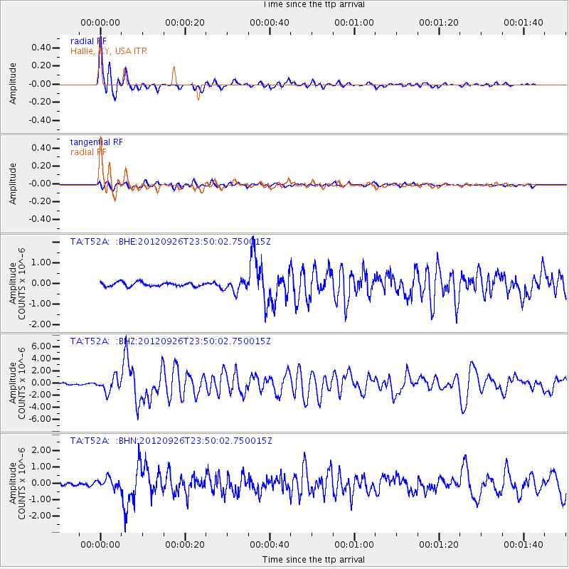
Earthquake location: Andreanof Islands, Aleutian Is.
Earthquake latitude/longitude: 51.6/-178.3
Earthquake time(UTC): 2012/09/26 (270) 23:39:55 GMT
Earthquake Depth: 16 km
Earthquake Magnitude: 6.3 MB, 6.5 MS, 6.4 MW, 6.4 MW
Earthquake Catalog/Contributor: WHDF/NEIC
Network: TA USArray Transportable Network (new EarthScope stations)
Station: T52A Hallie, KY, USA
Lat/Lon: 37.11 N/82.99 W
Elevation: 436 m
Distance: 65.0 deg
Az: 61.479 deg
Baz: 316.716 deg
Ray Param: 0.058577716
Estimated Moho Depth: 13.5 km
Estimated Crust Vp/Vs: 1.98
Assumed Crust Vp: 6.476 km/s
Estimated Crust Vs: 3.279 km/s
Estimated Crust Poisson's Ratio: 0.33
Radial Match: 94.71621 %
Radial Bump: 400
Transverse Match: 81.617874 %
Transverse Bump: 400
SOD ConfigId: 478790
Insert Time: 2013-02-22 23:49:35.683 +0000
GWidth: 2.5
Max Bumps: 400
Tol: 0.001

Signal To Noise

ChannelStoNSTALTA
TA:T52A: :BHZ:20120926T23:50:02.750015Z10.9765361.1927485E-61.0866347E-7
TA:T52A: :BHN:20120926T23:50:02.750015Z3.19684122.8993955E-79.069563E-8
TA:T52A: :BHE:20120926T23:50:02.750015Z2.90485142.7989512E-79.635437E-8
Arrivals
Ps2.1 SECOND
PpPs6.0 SECOND
PsPs/PpSs8.1 SECOND