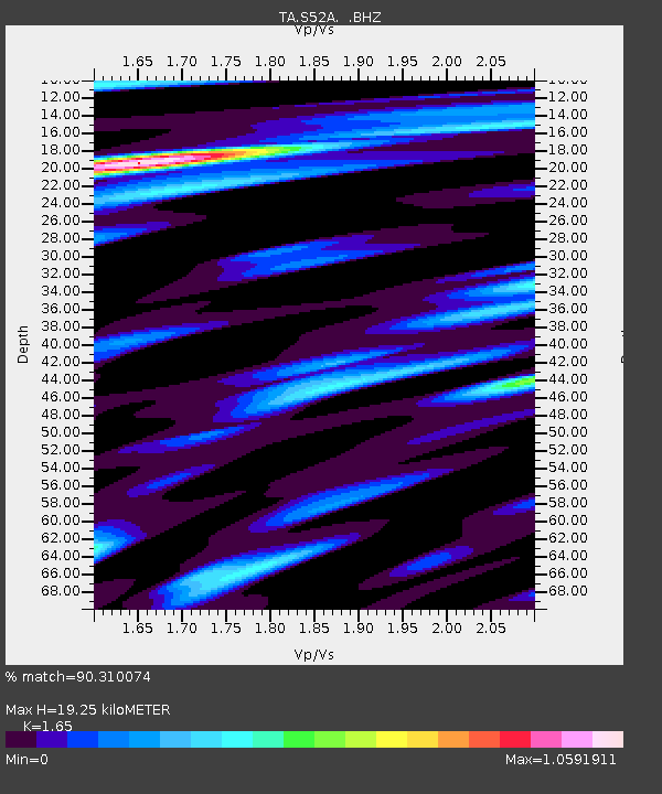
S52A Salyersville, KY, USA - Earthquake Result Viewer
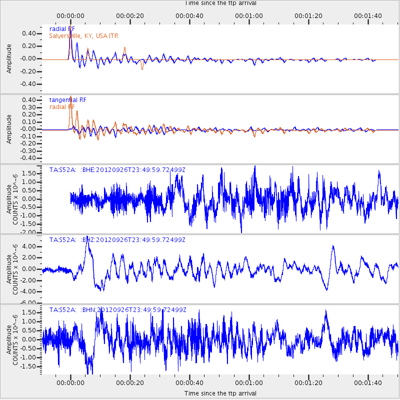
Earthquake location: Andreanof Islands, Aleutian Is.
Earthquake latitude/longitude: 51.6/-178.3
Earthquake time(UTC): 2012/09/26 (270) 23:39:55 GMT
Earthquake Depth: 16 km
Earthquake Magnitude: 6.3 MB, 6.5 MS, 6.4 MW, 6.4 MW
Earthquake Catalog/Contributor: WHDF/NEIC
Network: TA USArray Transportable Network (new EarthScope stations)
Station: S52A Salyersville, KY, USA
Lat/Lon: 37.68 N/83.08 W
Elevation: 367 m
Distance: 64.5 deg
Az: 61.106 deg
Baz: 316.5 deg
Ray Param: 0.058877833
Estimated Moho Depth: 19.25 km
Estimated Crust Vp/Vs: 1.65
Assumed Crust Vp: 6.476 km/s
Estimated Crust Vs: 3.925 km/s
Estimated Crust Poisson's Ratio: 0.21
Radial Match: 90.310074 %
Radial Bump: 400
Transverse Match: 78.69748 %
Transverse Bump: 400
SOD ConfigId: 478790
Insert Time: 2013-02-22 23:49:49.401 +0000
GWidth: 2.5
Max Bumps: 400
Tol: 0.001

Signal To Noise

ChannelStoNSTALTA
TA:S52A: :BHZ:20120926T23:49:59.72499Z3.79549988.9444234E-72.3565865E-7
TA:S52A: :BHN:20120926T23:49:59.72499Z1.402544.3021527E-73.067401E-7
TA:S52A: :BHE:20120926T23:49:59.72499Z1.45811194.768912E-73.270608E-7
Arrivals
Ps2.0 SECOND
PpPs7.5 SECOND
PsPs/PpSs9.5 SECOND