V53A Saluda, NC, USA - Earthquake Result Viewer
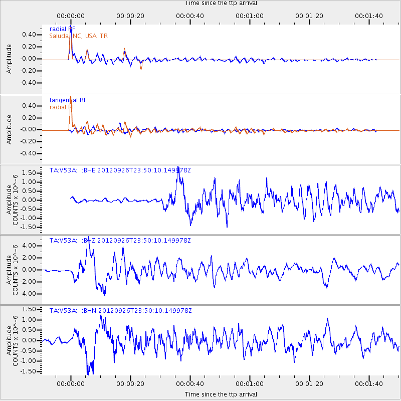
Earthquake location: Andreanof Islands, Aleutian Is.
Earthquake latitude/longitude: 51.6/-178.3
Earthquake time(UTC): 2012/09/26 (270) 23:39:55 GMT
Earthquake Depth: 16 km
Earthquake Magnitude: 6.3 MB, 6.5 MS, 6.4 MW, 6.4 MW
Earthquake Catalog/Contributor: WHDF/NEIC
Network: TA USArray Transportable Network (new EarthScope stations)
Station: V53A Saluda, NC, USA
Lat/Lon: 35.67 N/82.81 W
Elevation: 681 m
Distance: 66.1 deg
Az: 62.444 deg
Baz: 317.217 deg
Ray Param: 0.057826795
Estimated Moho Depth: 43.25 km
Estimated Crust Vp/Vs: 1.78
Assumed Crust Vp: 6.35 km/s
Estimated Crust Vs: 3.562 km/s
Estimated Crust Poisson's Ratio: 0.27
Radial Match: 95.513115 %
Radial Bump: 333
Transverse Match: 85.55136 %
Transverse Bump: 400
SOD ConfigId: 478790
Insert Time: 2013-02-22 23:50:02.211 +0000
GWidth: 2.5
Max Bumps: 400
Tol: 0.001

Signal To Noise

ChannelStoNSTALTA
TA:V53A: :BHZ:20120926T23:50:10.149978Z13.0002099.393274E-77.225479E-8
TA:V53A: :BHN:20120926T23:50:10.149978Z4.80140972.7260663E-75.677637E-8
TA:V53A: :BHE:20120926T23:50:10.149978Z3.88016942.6117505E-76.731022E-8
Arrivals
Ps5.5 SECOND
PpPs18 SECOND
PsPs/PpSs24 SECOND