S50A Richmond, KY, USA - Earthquake Result Viewer
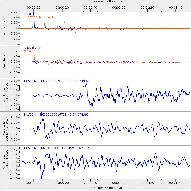
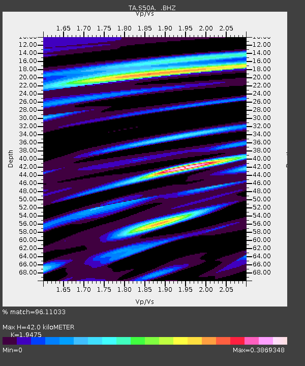
Earthquake location: Andreanof Islands, Aleutian Is.
Earthquake latitude/longitude: 51.6/-178.3
Earthquake time(UTC): 2012/09/26 (270) 23:39:55 GMT
Earthquake Depth: 16 km
Earthquake Magnitude: 6.3 MB, 6.5 MS, 6.4 MW, 6.4 MW
Earthquake Catalog/Contributor: WHDF/NEIC
Network: TA USArray Transportable Network (new EarthScope stations)
Station: S50A Richmond, KY, USA
Lat/Lon: 37.68 N/84.40 W
Elevation: 300 m
Distance: 63.8 deg
Az: 61.948 deg
Baz: 316.063 deg
Ray Param: 0.05935275
Estimated Moho Depth: 42.0 km
Estimated Crust Vp/Vs: 1.95
Assumed Crust Vp: 6.476 km/s
Estimated Crust Vs: 3.325 km/s
Estimated Crust Poisson's Ratio: 0.32
Radial Match: 96.11033 %
Radial Bump: 195
Transverse Match: 83.71572 %
Transverse Bump: 400
SOD ConfigId: 478790
Insert Time: 2013-02-22 23:50:58.180 +0000
GWidth: 2.5
Max Bumps: 400
Tol: 0.001

Signal To Noise

ChannelStoNSTALTA
TA:S50A: :BHZ:20120926T23:49:54.97499Z10.7608249.1163594E-78.471804E-8
TA:S50A: :BHN:20120926T23:49:54.97499Z4.2156833.3463E-77.937741E-8
TA:S50A: :BHE:20120926T23:49:54.97499Z3.02577692.408202E-77.958954E-8
Arrivals
Ps6.4 SECOND
PpPs18 SECOND
PsPs/PpSs25 SECOND