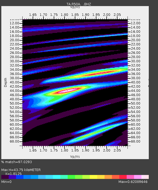
R50A Paris, KY, USA - Earthquake Result Viewer

Earthquake location: Andreanof Islands, Aleutian Is.
Earthquake latitude/longitude: 51.6/-178.3
Earthquake time(UTC): 2012/09/26 (270) 23:39:55 GMT
Earthquake Depth: 16 km
Earthquake Magnitude: 6.3 MB, 6.5 MS, 6.4 MW, 6.4 MW
Earthquake Catalog/Contributor: WHDF/NEIC
Network: TA USArray Transportable Network (new EarthScope stations)
Station: R50A Paris, KY, USA
Lat/Lon: 38.28 N/84.33 W
Elevation: 255 m
Distance: 63.4 deg
Az: 61.435 deg
Baz: 315.879 deg
Ray Param: 0.05960818
Estimated Moho Depth: 43.75 km
Estimated Crust Vp/Vs: 1.81
Assumed Crust Vp: 6.498 km/s
Estimated Crust Vs: 3.585 km/s
Estimated Crust Poisson's Ratio: 0.28
Radial Match: 97.0293 %
Radial Bump: 232
Transverse Match: 78.700035 %
Transverse Bump: 400
SOD ConfigId: 478790
Insert Time: 2013-02-22 23:51:36.131 +0000
GWidth: 2.5
Max Bumps: 400
Tol: 0.001

Signal To Noise

ChannelStoNSTALTA
TA:R50A: :BHZ:20120926T23:49:52.375015Z8.2363949.837911E-71.194444E-7
TA:R50A: :BHN:20120926T23:49:52.375015Z4.50746733.0138594E-76.68637E-8
TA:R50A: :BHE:20120926T23:49:52.375015Z2.65891033.2713086E-71.2303192E-7
Arrivals
Ps5.7 SECOND
PpPs18 SECOND
PsPs/PpSs24 SECOND