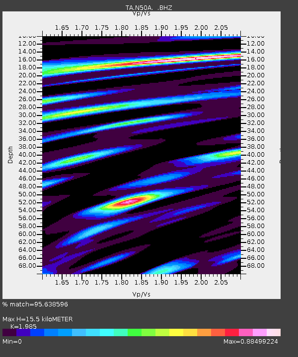
N50A Nevada, OH, USA - Earthquake Result Viewer
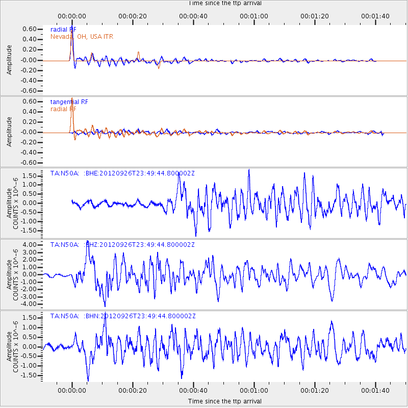
Earthquake location: Andreanof Islands, Aleutian Is.
Earthquake latitude/longitude: 51.6/-178.3
Earthquake time(UTC): 2012/09/26 (270) 23:39:55 GMT
Earthquake Depth: 16 km
Earthquake Magnitude: 6.3 MB, 6.5 MS, 6.4 MW, 6.4 MW
Earthquake Catalog/Contributor: WHDF/NEIC
Network: TA USArray Transportable Network (new EarthScope stations)
Station: N50A Nevada, OH, USA
Lat/Lon: 40.77 N/83.15 W
Elevation: 277 m
Distance: 62.2 deg
Az: 58.748 deg
Baz: 315.398 deg
Ray Param: 0.060350746
Estimated Moho Depth: 15.5 km
Estimated Crust Vp/Vs: 1.99
Assumed Crust Vp: 6.498 km/s
Estimated Crust Vs: 3.273 km/s
Estimated Crust Poisson's Ratio: 0.33
Radial Match: 95.638596 %
Radial Bump: 313
Transverse Match: 73.25463 %
Transverse Bump: 400
SOD ConfigId: 478790
Insert Time: 2013-02-22 23:51:49.165 +0000
GWidth: 2.5
Max Bumps: 400
Tol: 0.001

Signal To Noise

ChannelStoNSTALTA
TA:N50A: :BHZ:20120926T23:49:44.800002Z7.7079081.0424054E-61.3523844E-7
TA:N50A: :BHN:20120926T23:49:44.800002Z2.7434883.4317415E-71.2508681E-7
TA:N50A: :BHE:20120926T23:49:44.800002Z2.76480413.2388232E-71.17144765E-7
Arrivals
Ps2.4 SECOND
PpPs6.8 SECOND
PsPs/PpSs9.3 SECOND