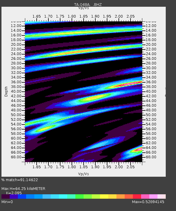
Q48A North Vernon, IN, USA - Earthquake Result Viewer
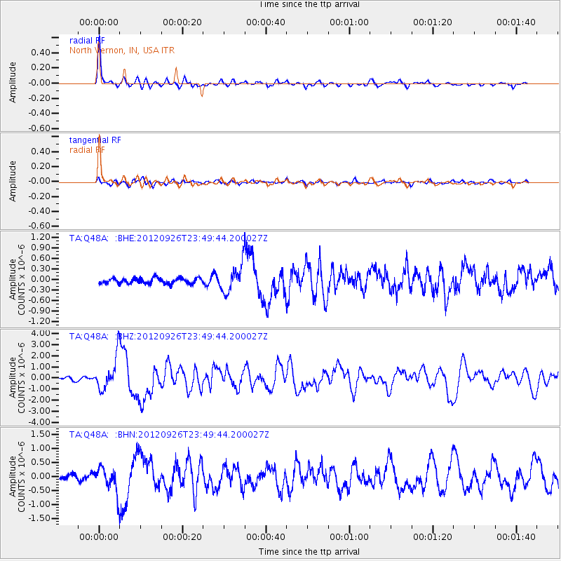
Earthquake location: Andreanof Islands, Aleutian Is.
Earthquake latitude/longitude: 51.6/-178.3
Earthquake time(UTC): 2012/09/26 (270) 23:39:55 GMT
Earthquake Depth: 16 km
Earthquake Magnitude: 6.3 MB, 6.5 MS, 6.4 MW, 6.4 MW
Earthquake Catalog/Contributor: WHDF/NEIC
Network: TA USArray Transportable Network (new EarthScope stations)
Station: Q48A North Vernon, IN, USA
Lat/Lon: 38.93 N/85.73 W
Elevation: 185 m
Distance: 62.1 deg
Az: 61.808 deg
Baz: 315.178 deg
Ray Param: 0.060411587
Estimated Moho Depth: 64.25 km
Estimated Crust Vp/Vs: 2.10
Assumed Crust Vp: 6.498 km/s
Estimated Crust Vs: 3.101 km/s
Estimated Crust Poisson's Ratio: 0.35
Radial Match: 91.14622 %
Radial Bump: 353
Transverse Match: 79.95807 %
Transverse Bump: 400
SOD ConfigId: 478790
Insert Time: 2013-02-22 23:52:03.293 +0000
GWidth: 2.5
Max Bumps: 400
Tol: 0.001

Signal To Noise

ChannelStoNSTALTA
TA:Q48A: :BHZ:20120926T23:49:44.200027Z9.4327131.534758E-61.627059E-7
TA:Q48A: :BHN:20120926T23:49:44.200027Z4.51024874.372561E-79.6947225E-8
TA:Q48A: :BHE:20120926T23:49:44.200027Z5.04641443.9702252E-77.867418E-8
Arrivals
Ps11 SECOND
PpPs29 SECOND
PsPs/PpSs41 SECOND