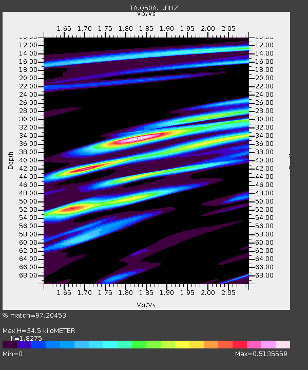
Q50A Georgetown, OH, USA - Earthquake Result Viewer

Earthquake location: Andreanof Islands, Aleutian Is.
Earthquake latitude/longitude: 51.6/-178.3
Earthquake time(UTC): 2012/09/26 (270) 23:39:55 GMT
Earthquake Depth: 16 km
Earthquake Magnitude: 6.3 MB, 6.5 MS, 6.4 MW, 6.4 MW
Earthquake Catalog/Contributor: WHDF/NEIC
Network: TA USArray Transportable Network (new EarthScope stations)
Station: Q50A Georgetown, OH, USA
Lat/Lon: 38.84 N/83.98 W
Elevation: 262 m
Distance: 63.2 deg
Az: 60.778 deg
Baz: 315.8 deg
Ray Param: 0.059745602
Estimated Moho Depth: 34.5 km
Estimated Crust Vp/Vs: 1.83
Assumed Crust Vp: 6.232 km/s
Estimated Crust Vs: 3.41 km/s
Estimated Crust Poisson's Ratio: 0.29
Radial Match: 97.20453 %
Radial Bump: 243
Transverse Match: 78.49925 %
Transverse Bump: 400
SOD ConfigId: 478790
Insert Time: 2013-02-22 23:52:14.256 +0000
GWidth: 2.5
Max Bumps: 400
Tol: 0.001

Signal To Noise

ChannelStoNSTALTA
TA:Q50A: :BHZ:20120926T23:49:50.97499Z12.4146521.2055954E-69.7110686E-8
TA:Q50A: :BHN:20120926T23:49:50.97499Z4.683634.2877716E-79.154804E-8
TA:Q50A: :BHE:20120926T23:49:50.97499Z6.08425335.74378E-79.440402E-8
Arrivals
Ps4.8 SECOND
PpPs15 SECOND
PsPs/PpSs20 SECOND