M50A Fremont, OH, USA - Earthquake Result Viewer
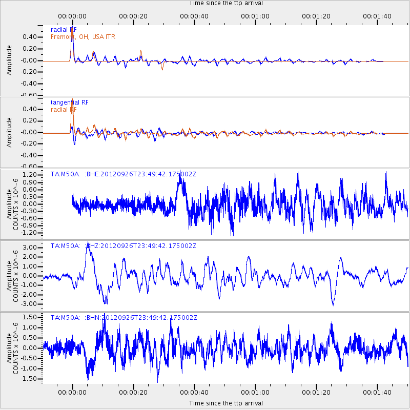
Earthquake location: Andreanof Islands, Aleutian Is.
Earthquake latitude/longitude: 51.6/-178.3
Earthquake time(UTC): 2012/09/26 (270) 23:39:55 GMT
Earthquake Depth: 16 km
Earthquake Magnitude: 6.3 MB, 6.5 MS, 6.4 MW, 6.4 MW
Earthquake Catalog/Contributor: WHDF/NEIC
Network: TA USArray Transportable Network (new EarthScope stations)
Station: M50A Fremont, OH, USA
Lat/Lon: 41.40 N/83.04 W
Elevation: 176 m
Distance: 61.8 deg
Az: 58.18 deg
Baz: 315.201 deg
Ray Param: 0.060607515
Estimated Moho Depth: 19.0 km
Estimated Crust Vp/Vs: 1.61
Assumed Crust Vp: 6.498 km/s
Estimated Crust Vs: 4.048 km/s
Estimated Crust Poisson's Ratio: 0.18
Radial Match: 93.18864 %
Radial Bump: 351
Transverse Match: 84.21782 %
Transverse Bump: 400
SOD ConfigId: 478790
Insert Time: 2013-02-22 23:52:44.841 +0000
GWidth: 2.5
Max Bumps: 400
Tol: 0.001

Signal To Noise

ChannelStoNSTALTA
TA:M50A: :BHZ:20120926T23:49:42.175002Z7.30058961.032746E-61.4146065E-7
TA:M50A: :BHN:20120926T23:49:42.175002Z1.9809463.571166E-71.8027579E-7
TA:M50A: :BHE:20120926T23:49:42.175002Z1.96162833.2819386E-71.6730685E-7
Arrivals
Ps1.9 SECOND
PpPs7.2 SECOND
PsPs/PpSs9.1 SECOND