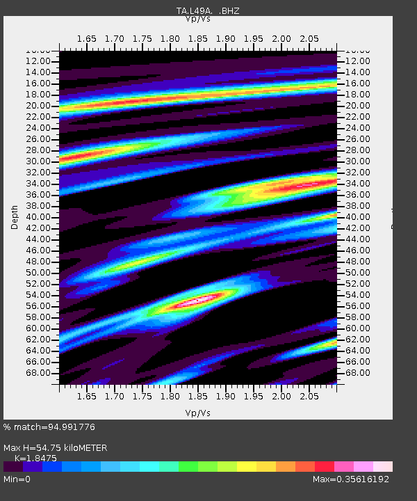
L49A Milan, MI, USA - Earthquake Result Viewer
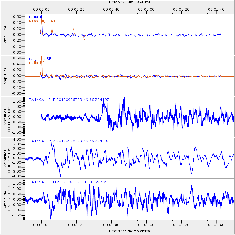
Earthquake location: Andreanof Islands, Aleutian Is.
Earthquake latitude/longitude: 51.6/-178.3
Earthquake time(UTC): 2012/09/26 (270) 23:39:55 GMT
Earthquake Depth: 16 km
Earthquake Magnitude: 6.3 MB, 6.5 MS, 6.4 MW, 6.4 MW
Earthquake Catalog/Contributor: WHDF/NEIC
Network: TA USArray Transportable Network (new EarthScope stations)
Station: L49A Milan, MI, USA
Lat/Lon: 42.11 N/83.77 W
Elevation: 230 m
Distance: 61.0 deg
Az: 58.048 deg
Baz: 314.657 deg
Ray Param: 0.06117673
Estimated Moho Depth: 54.75 km
Estimated Crust Vp/Vs: 1.85
Assumed Crust Vp: 6.483 km/s
Estimated Crust Vs: 3.509 km/s
Estimated Crust Poisson's Ratio: 0.29
Radial Match: 94.991776 %
Radial Bump: 289
Transverse Match: 77.22991 %
Transverse Bump: 400
SOD ConfigId: 478790
Insert Time: 2013-02-22 23:52:51.397 +0000
GWidth: 2.5
Max Bumps: 400
Tol: 0.001

Signal To Noise

ChannelStoNSTALTA
TA:L49A: :BHZ:20120926T23:49:36.22499Z4.3858387.916776E-71.8050773E-7
TA:L49A: :BHN:20120926T23:49:36.22499Z1.98478693.0506052E-71.5369939E-7
TA:L49A: :BHE:20120926T23:49:36.22499Z1.80463912.7205593E-71.5075365E-7
Arrivals
Ps7.5 SECOND
PpPs23 SECOND
PsPs/PpSs30 SECOND