You are here: Home > Network List > G - GEOSCOPE Stations List
> Station WUS Wushi, Xinjiang Uygur, China > Earthquake Result Viewer
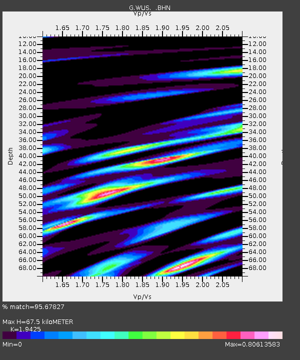
WUS Wushi, Xinjiang Uygur, China - Earthquake Result Viewer
| Earthquake location: |
Minahassa Peninsula, Sulawesi |
| Earthquake latitude/longitude: |
1.1/124.1 |
| Earthquake time(UTC): |
1992/06/10 (162) 02:13:45 GMT |
| Earthquake Depth: |
30 km |
| Earthquake Magnitude: |
5.7 MB, 5.8 MS |
| Earthquake Catalog/Contributor: |
WHDF/NEIC |
|
| Network: |
G GEOSCOPE |
| Station: |
WUS Wushi, Xinjiang Uygur, China |
| Lat/Lon: |
41.20 N/79.22 E |
| Elevation: |
1457 m |
|
| Distance: |
56.8 deg |
| Az: |
320.513 deg |
| Baz: |
122.59 deg |
| Ray Param: |
0.063826144 |
| Estimated Moho Depth: |
67.5 km |
| Estimated Crust Vp/Vs: |
1.94 |
| Assumed Crust Vp: |
6.353 km/s |
| Estimated Crust Vs: |
3.271 km/s |
| Estimated Crust Poisson's Ratio: |
0.32 |
|
| Radial Match: |
95.67827 % |
| Radial Bump: |
400 |
| Transverse Match: |
76.43262 % |
| Transverse Bump: |
400 |
| SOD ConfigId: |
17000 |
| Insert Time: |
2010-02-27 00:50:32.086 +0000 |
| GWidth: |
2.5 |
| Max Bumps: |
400 |
| Tol: |
0.001 |
|

Signal To Noise
| Channel | StoN | STA | LTA |
| G:WUS: :BHN:19920610T02:22:56.250012Z | 2.99508 | 1.7140404E-7 | 5.7228537E-8 |
| G:WUS: :BHE:19920610T02:22:56.250012Z | 6.650348 | 2.5295049E-7 | 3.8035676E-8 |
| G:WUS: :BHZ:19920610T02:22:56.250012Z | 7.7949886 | 5.500565E-7 | 7.05654E-8 |
| Arrivals |
| Ps | 10 SECOND |
| PpPs | 30 SECOND |
| PsPs/PpSs | 40 SECOND |


