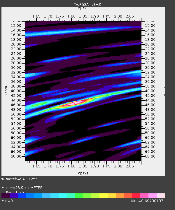
P53A Whipple, OH, USA - Earthquake Result Viewer

Earthquake location: Andreanof Islands, Aleutian Is.
Earthquake latitude/longitude: 51.6/-178.3
Earthquake time(UTC): 2012/09/26 (270) 23:39:55 GMT
Earthquake Depth: 16 km
Earthquake Magnitude: 6.3 MB, 6.5 MS, 6.4 MW, 6.4 MW
Earthquake Catalog/Contributor: WHDF/NEIC
Network: TA USArray Transportable Network (new EarthScope stations)
Station: P53A Whipple, OH, USA
Lat/Lon: 39.49 N/81.39 W
Elevation: 270 m
Distance: 64.1 deg
Az: 58.661 deg
Baz: 316.488 deg
Ray Param: 0.059135932
Estimated Moho Depth: 45.0 km
Estimated Crust Vp/Vs: 1.81
Assumed Crust Vp: 6.207 km/s
Estimated Crust Vs: 3.425 km/s
Estimated Crust Poisson's Ratio: 0.28
Radial Match: 94.11255 %
Radial Bump: 318
Transverse Match: 69.80548 %
Transverse Bump: 400
SOD ConfigId: 478790
Insert Time: 2013-02-22 23:53:48.167 +0000
GWidth: 2.5
Max Bumps: 400
Tol: 0.001

Signal To Noise

ChannelStoNSTALTA
TA:P53A: :BHZ:20120926T23:49:57.125015Z7.5422911.1490071E-61.5234191E-7
TA:P53A: :BHN:20120926T23:49:57.125015Z4.40520863.8415587E-78.7204924E-8
TA:P53A: :BHE:20120926T23:49:57.125015Z2.67875393.9718032E-71.4827056E-7
Arrivals
Ps6.1 SECOND
PpPs20 SECOND
PsPs/PpSs26 SECOND