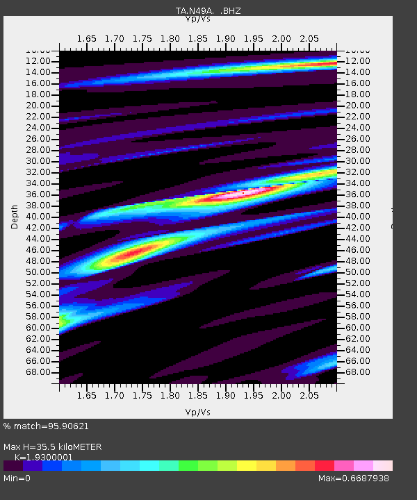
N49A Columbus Grove, OH, USA - Earthquake Result Viewer

Earthquake location: Andreanof Islands, Aleutian Is.
Earthquake latitude/longitude: 51.6/-178.3
Earthquake time(UTC): 2012/09/26 (270) 23:39:55 GMT
Earthquake Depth: 16 km
Earthquake Magnitude: 6.3 MB, 6.5 MS, 6.4 MW, 6.4 MW
Earthquake Catalog/Contributor: WHDF/NEIC
Network: TA USArray Transportable Network (new EarthScope stations)
Station: N49A Columbus Grove, OH, USA
Lat/Lon: 40.92 N/84.18 W
Elevation: 225 m
Distance: 61.6 deg
Az: 59.258 deg
Baz: 314.965 deg
Ray Param: 0.060776606
Estimated Moho Depth: 35.5 km
Estimated Crust Vp/Vs: 1.93
Assumed Crust Vp: 6.498 km/s
Estimated Crust Vs: 3.367 km/s
Estimated Crust Poisson's Ratio: 0.32
Radial Match: 95.90621 %
Radial Bump: 234
Transverse Match: 77.42378 %
Transverse Bump: 400
SOD ConfigId: 478790
Insert Time: 2013-02-22 23:54:01.275 +0000
GWidth: 2.5
Max Bumps: 400
Tol: 0.001

Signal To Noise

ChannelStoNSTALTA
TA:N49A: :BHZ:20120926T23:49:40.375015Z17.7354771.5329947E-68.643662E-8
TA:N49A: :BHN:20120926T23:49:40.375015Z4.49018535.24122E-71.1672615E-7
TA:N49A: :BHE:20120926T23:49:40.375015Z5.61046935.5214645E-79.8413594E-8
Arrivals
Ps5.3 SECOND
PpPs15 SECOND
PsPs/PpSs21 SECOND