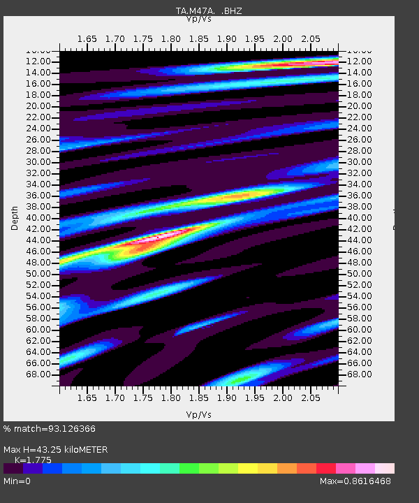
M47A Cromwell, IN, USA - Earthquake Result Viewer
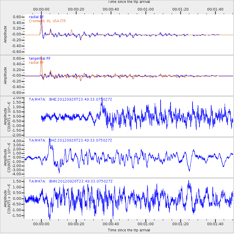
Earthquake location: Andreanof Islands, Aleutian Is.
Earthquake latitude/longitude: 51.6/-178.3
Earthquake time(UTC): 2012/09/26 (270) 23:39:55 GMT
Earthquake Depth: 16 km
Earthquake Magnitude: 6.3 MB, 6.5 MS, 6.4 MW, 6.4 MW
Earthquake Catalog/Contributor: WHDF/NEIC
Network: TA USArray Transportable Network (new EarthScope stations)
Station: M47A Cromwell, IN, USA
Lat/Lon: 41.36 N/85.62 W
Elevation: 283 m
Distance: 60.5 deg
Az: 59.775 deg
Baz: 314.272 deg
Ray Param: 0.061484795
Estimated Moho Depth: 43.25 km
Estimated Crust Vp/Vs: 1.77
Assumed Crust Vp: 6.498 km/s
Estimated Crust Vs: 3.661 km/s
Estimated Crust Poisson's Ratio: 0.27
Radial Match: 93.126366 %
Radial Bump: 355
Transverse Match: 72.59552 %
Transverse Bump: 400
SOD ConfigId: 478790
Insert Time: 2013-02-22 23:54:14.488 +0000
GWidth: 2.5
Max Bumps: 400
Tol: 0.001

Signal To Noise

ChannelStoNSTALTA
TA:M47A: :BHZ:20120926T23:49:33.075027Z8.1002021.5176585E-61.8736057E-7
TA:M47A: :BHN:20120926T23:49:33.075027Z3.66851356.2144716E-71.6940027E-7
TA:M47A: :BHE:20120926T23:49:33.075027Z3.21744825.9009403E-71.8340437E-7
Arrivals
Ps5.4 SECOND
PpPs18 SECOND
PsPs/PpSs23 SECOND