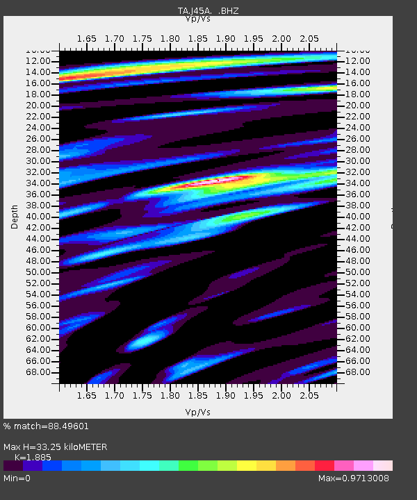
J45A Montague, MI, USA - Earthquake Result Viewer
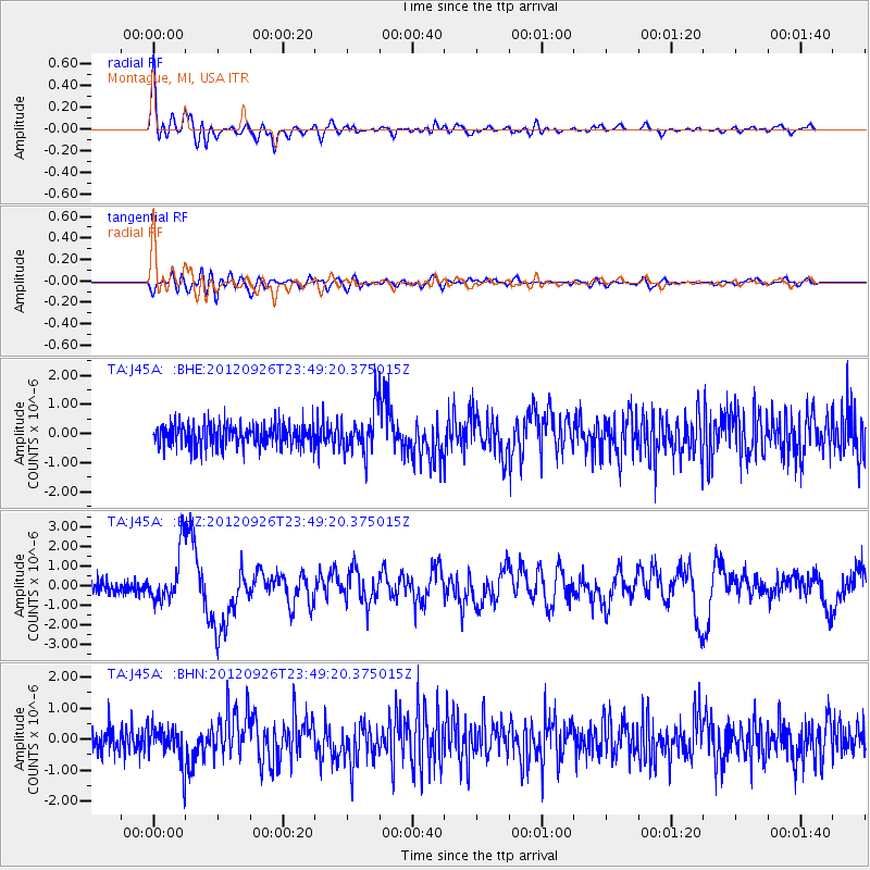
Earthquake location: Andreanof Islands, Aleutian Is.
Earthquake latitude/longitude: 51.6/-178.3
Earthquake time(UTC): 2012/09/26 (270) 23:39:55 GMT
Earthquake Depth: 16 km
Earthquake Magnitude: 6.3 MB, 6.5 MS, 6.4 MW, 6.4 MW
Earthquake Catalog/Contributor: WHDF/NEIC
Network: TA USArray Transportable Network (new EarthScope stations)
Station: J45A Montague, MI, USA
Lat/Lon: 43.44 N/86.39 W
Elevation: 209 m
Distance: 58.6 deg
Az: 58.491 deg
Baz: 313.106 deg
Ray Param: 0.06269561
Estimated Moho Depth: 33.25 km
Estimated Crust Vp/Vs: 1.88
Assumed Crust Vp: 6.483 km/s
Estimated Crust Vs: 3.439 km/s
Estimated Crust Poisson's Ratio: 0.30
Radial Match: 88.49601 %
Radial Bump: 400
Transverse Match: 69.294945 %
Transverse Bump: 400
SOD ConfigId: 478790
Insert Time: 2013-02-22 23:54:56.693 +0000
GWidth: 2.5
Max Bumps: 400
Tol: 0.001

Signal To Noise

ChannelStoNSTALTA
TA:J45A: :BHZ:20120926T23:49:20.375015Z4.7946671.3135538E-62.7396143E-7
TA:J45A: :BHN:20120926T23:49:20.375015Z1.43398486.0518386E-74.2202947E-7
TA:J45A: :BHE:20120926T23:49:20.375015Z1.88773577.4600223E-73.951836E-7
Arrivals
Ps4.8 SECOND
PpPs14 SECOND
PsPs/PpSs19 SECOND