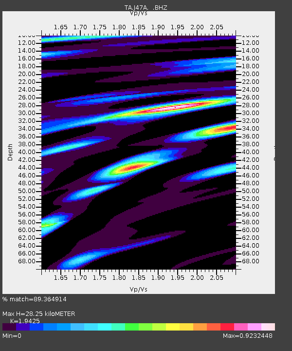
J47A Sunmer, MI, USA - Earthquake Result Viewer
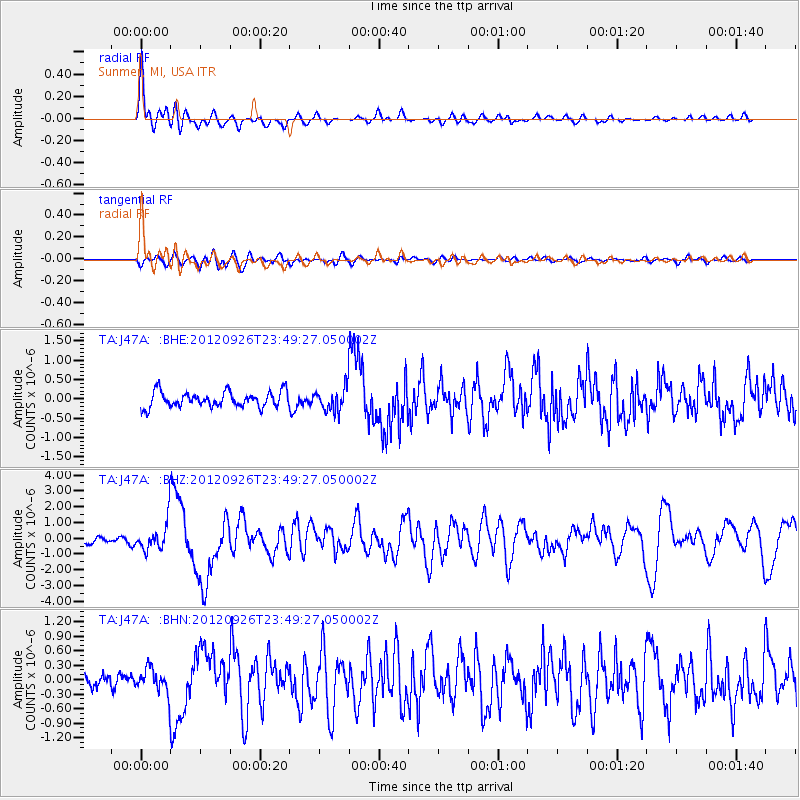
Earthquake location: Andreanof Islands, Aleutian Is.
Earthquake latitude/longitude: 51.6/-178.3
Earthquake time(UTC): 2012/09/26 (270) 23:39:55 GMT
Earthquake Depth: 16 km
Earthquake Magnitude: 6.3 MB, 6.5 MS, 6.4 MW, 6.4 MW
Earthquake Catalog/Contributor: WHDF/NEIC
Network: TA USArray Transportable Network (new EarthScope stations)
Station: J47A Sunmer, MI, USA
Lat/Lon: 43.24 N/84.82 W
Elevation: 236 m
Distance: 59.6 deg
Az: 57.741 deg
Baz: 313.793 deg
Ray Param: 0.06206028
Estimated Moho Depth: 28.25 km
Estimated Crust Vp/Vs: 1.94
Assumed Crust Vp: 6.483 km/s
Estimated Crust Vs: 3.337 km/s
Estimated Crust Poisson's Ratio: 0.32
Radial Match: 89.364914 %
Radial Bump: 400
Transverse Match: 71.67891 %
Transverse Bump: 400
SOD ConfigId: 478790
Insert Time: 2013-02-22 23:55:09.738 +0000
GWidth: 2.5
Max Bumps: 400
Tol: 0.001

Signal To Noise

ChannelStoNSTALTA
TA:J47A: :BHZ:20120926T23:49:27.050002Z4.5966479.1826183E-71.9976777E-7
TA:J47A: :BHN:20120926T23:49:27.050002Z1.89995962.4838323E-71.307308E-7
TA:J47A: :BHE:20120926T23:49:27.050002Z1.48133992.9600733E-71.9982404E-7
Arrivals
Ps4.3 SECOND
PpPs12 SECOND
PsPs/PpSs17 SECOND