You are here: Home > Network List > UW - Pacific Northwest Regional Seismic Network Stations List
> Station KENT Carlson Farm, Grass Valley, OR, USA > Earthquake Result Viewer
KENT Carlson Farm, Grass Valley, OR, USA - Earthquake Result Viewer
| Earthquake location: |
Andreanof Islands, Aleutian Is. |
| Earthquake latitude/longitude: |
51.6/-178.3 |
| Earthquake time(UTC): |
2012/09/26 (270) 23:39:55 GMT |
| Earthquake Depth: |
16 km |
| Earthquake Magnitude: |
6.3 MB, 6.5 MS, 6.4 MW, 6.4 MW |
| Earthquake Catalog/Contributor: |
WHDF/NEIC |
|
| Network: |
UW Pacific Northwest Regional Seismic Network |
| Station: |
KENT Carlson Farm, Grass Valley, OR, USA |
| Lat/Lon: |
45.24 N/120.64 W |
| Elevation: |
780 m |
|
| Distance: |
37.9 deg |
| Az: |
76.255 deg |
| Baz: |
300.952 deg |
| Ray Param: |
0.07584556 |
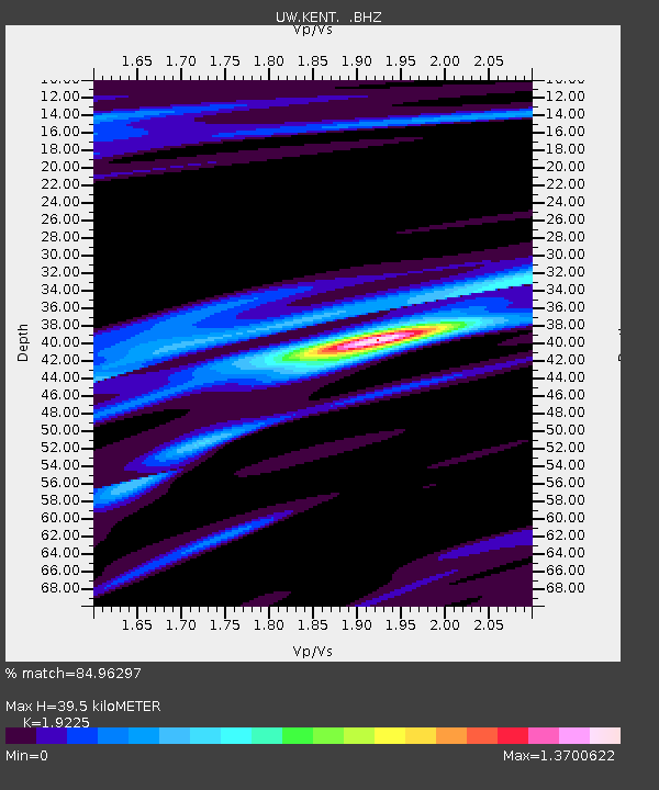
| Estimated Moho Depth: |
39.5 km |
| Estimated Crust Vp/Vs: |
1.92 |
| Assumed Crust Vp: |
6.597 km/s |
| Estimated Crust Vs: |
3.432 km/s |
| Estimated Crust Poisson's Ratio: |
0.31 |
|
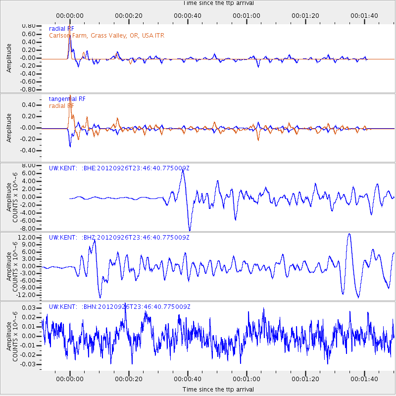
| Radial Match: |
84.96297 % |
| Radial Bump: |
313 |
| Transverse Match: |
84.97036 % |
| Transverse Bump: |
323 |
| SOD ConfigId: |
478790 |
| Insert Time: |
2013-02-22 23:56:31.850 +0000 |
| GWidth: |
2.5 |
| Max Bumps: |
400 |
| Tol: |
0.001 |
|
Signal To Noise
| Channel | StoN | STA | LTA |
| UW:KENT: :BHZ:20120926T23:46:40.775009Z | 8.520397 | 2.2033576E-6 | 2.58598E-7 |
| UW:KENT: :BHN:20120926T23:46:40.775009Z | 1.1397617 | 1.1133602E-8 | 9.7683595E-9 |
| UW:KENT: :BHE:20120926T23:46:40.775009Z | 4.412351 | 8.2125337E-7 | 1.8612603E-7 |
| Arrivals |
| Ps | 5.9 SECOND |
| PpPs | 16 SECOND |
| PsPs/PpSs | 22 SECOND |


