You are here: Home > Network List > G - GEOSCOPE Stations List
> Station WUS Wushi, Xinjiang Uygur, China > Earthquake Result Viewer
WUS Wushi, Xinjiang Uygur, China - Earthquake Result Viewer
| Earthquake location: |
Off East Coast Of Honshu, Japan |
| Earthquake latitude/longitude: |
39.3/143.2 |
| Earthquake time(UTC): |
1992/07/16 (198) 00:00:40 GMT |
| Earthquake Depth: |
30 km |
| Earthquake Magnitude: |
5.5 MB, 5.8 MS |
| Earthquake Catalog/Contributor: |
WHDF/NEIC |
|
| Network: |
G GEOSCOPE |
| Station: |
WUS Wushi, Xinjiang Uygur, China |
| Lat/Lon: |
41.20 N/79.22 E |
| Elevation: |
1457 m |
|
| Distance: |
47.9 deg |
| Az: |
293.875 deg |
| Baz: |
70.017 deg |
| Ray Param: |
0.06964927 |
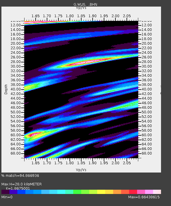
| Estimated Moho Depth: |
28.0 km |
| Estimated Crust Vp/Vs: |
1.87 |
| Assumed Crust Vp: |
6.353 km/s |
| Estimated Crust Vs: |
3.402 km/s |
| Estimated Crust Poisson's Ratio: |
0.30 |
|
| Radial Match: |
94.866936 % |
| Radial Bump: |
373 |
| Transverse Match: |
87.10366 % |
| Transverse Bump: |
400 |
| SOD ConfigId: |
17000 |
| Insert Time: |
2010-02-27 00:50:44.068 +0000 |
| GWidth: |
2.5 |
| Max Bumps: |
400 |
| Tol: |
0.001 |
|
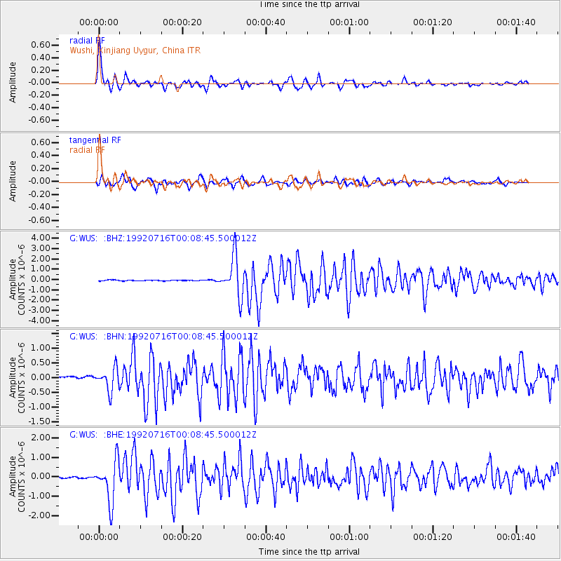
Signal To Noise
| Channel | StoN | STA | LTA |
| G:WUS: :BHN:19920716T00:08:45.500012Z | 3.6826472 | 3.911356E-7 | 1.0621044E-7 |
| G:WUS: :BHE:19920716T00:08:45.500012Z | 36.911766 | 1.0981256E-6 | 2.9750016E-8 |
| G:WUS: :BHZ:19920716T00:08:45.500012Z | 50.401566 | 2.0096845E-6 | 3.9873456E-8 |
| Arrivals |
| Ps | 4.0 SECOND |
| PpPs | 12 SECOND |
| PsPs/PpSs | 16 SECOND |


