You are here: Home > Network List > YB13 - Continental Dynamics/Cent. Anatolian Tectonics:Surface to Mantle Dynamics During Stations List
> Station AT34 Yesilkoy,Adana,Turkey > Earthquake Result Viewer
AT34 Yesilkoy,Adana,Turkey - Earthquake Result Viewer
| Earthquake location: |
Near East Coast Of Honshu, Japan |
| Earthquake latitude/longitude: |
37.1/141.1 |
| Earthquake time(UTC): |
2014/06/15 (166) 20:14:50 GMT |
| Earthquake Depth: |
40 km |
| Earthquake Magnitude: |
5.6 MB |
| Earthquake Catalog/Contributor: |
NEIC PDE/NEIC COMCAT |
|
| Network: |
YB Continental Dynamics/Cent. Anatolian Tectonics:Surface to Mantle Dynamics During |
| Station: |
AT34 Yesilkoy,Adana,Turkey |
| Lat/Lon: |
37.91 N/35.51 E |
| Elevation: |
1097 m |
|
| Distance: |
78.6 deg |
| Az: |
308.977 deg |
| Baz: |
51.779 deg |
| Ray Param: |
0.04947814 |
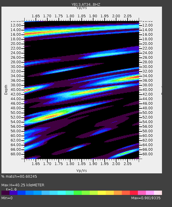
| Estimated Moho Depth: |
40.25 km |
| Estimated Crust Vp/Vs: |
1.60 |
| Assumed Crust Vp: |
6.247 km/s |
| Estimated Crust Vs: |
3.904 km/s |
| Estimated Crust Poisson's Ratio: |
0.18 |
|
| Radial Match: |
80.68245 % |
| Radial Bump: |
400 |
| Transverse Match: |
72.46858 % |
| Transverse Bump: |
400 |
| SOD ConfigId: |
3390531 |
| Insert Time: |
2019-04-12 07:05:28.822 +0000 |
| GWidth: |
2.5 |
| Max Bumps: |
400 |
| Tol: |
0.001 |
|

Signal To Noise
| Channel | StoN | STA | LTA |
| YB:AT34: :BHZ:20140615T20:26:16.480005Z | 11.401784 | 6.6713875E-7 | 5.8511784E-8 |
| YB:AT34: :BHN:20140615T20:26:16.480005Z | 5.9867 | 2.0972206E-7 | 3.503133E-8 |
| YB:AT34: :BHE:20140615T20:26:16.480005Z | 4.213912 | 1.718614E-7 | 4.078429E-8 |
| Arrivals |
| Ps | 4.0 SECOND |
| PpPs | 16 SECOND |
| PsPs/PpSs | 20 SECOND |


