You are here: Home > Network List > TA - USArray Transportable Network (new EarthScope stations) Stations List
> Station D41A Chassel, MI, USA > Earthquake Result Viewer
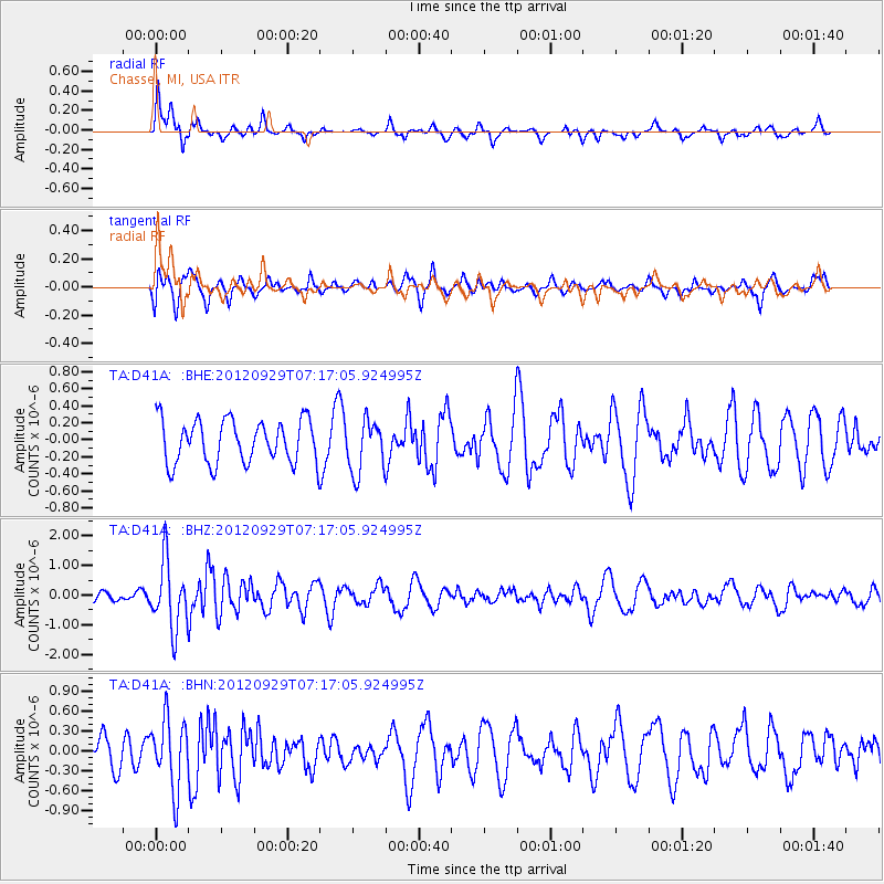
D41A Chassel, MI, USA - Earthquake Result Viewer
*The percent match for this event was below the threshold and hence no stack was calculated.
| Earthquake location: |
Near Coast Of Guerrero, Mexico |
| Earthquake latitude/longitude: |
16.3/-98.4 |
| Earthquake time(UTC): |
2012/09/29 (273) 07:11:12 GMT |
| Earthquake Depth: |
12 km |
| Earthquake Magnitude: |
5.5 MW, 4.9 MS, 5.3 MB, 5.4 MW |
| Earthquake Catalog/Contributor: |
WHDF/NEIC |
|
| Network: |
TA USArray Transportable Network (new EarthScope stations) |
| Station: |
D41A Chassel, MI, USA |
| Lat/Lon: |
47.06 N/88.57 W |
| Elevation: |
271 m |
|
| Distance: |
31.7 deg |
| Az: |
12.818 deg |
| Baz: |
198.157 deg |
| Ray Param: |
$rayparam |
*The percent match for this event was below the threshold and hence was not used in the summary stack. |
|
| Radial Match: |
77.238205 % |
| Radial Bump: |
400 |
| Transverse Match: |
50.60947 % |
| Transverse Bump: |
400 |
| SOD ConfigId: |
478790 |
| Insert Time: |
2013-02-23 00:21:44.556 +0000 |
| GWidth: |
2.5 |
| Max Bumps: |
400 |
| Tol: |
0.001 |
|
Signal To Noise
| Channel | StoN | STA | LTA |
| TA:D41A: :BHZ:20120929T07:17:05.924995Z | 7.7457137 | 1.117539E-6 | 1.4427837E-7 |
| TA:D41A: :BHN:20120929T07:17:05.924995Z | 2.2928212 | 5.271615E-7 | 2.2991827E-7 |
| TA:D41A: :BHE:20120929T07:17:05.924995Z | 1.2257452 | 3.096571E-7 | 2.5262764E-7 |
| Arrivals |
| Ps | |
| PpPs | |
| PsPs/PpSs | |


