You are here: Home > Network List > UW - Pacific Northwest Regional Seismic Network Stations List
> Station OMAK Colville Reservation, Omak, WA, USA > Earthquake Result Viewer
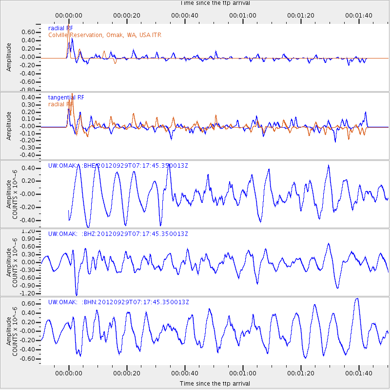
OMAK Colville Reservation, Omak, WA, USA - Earthquake Result Viewer
*The percent match for this event was below the threshold and hence no stack was calculated.
| Earthquake location: |
Near Coast Of Guerrero, Mexico |
| Earthquake latitude/longitude: |
16.3/-98.4 |
| Earthquake time(UTC): |
2012/09/29 (273) 07:11:12 GMT |
| Earthquake Depth: |
12 km |
| Earthquake Magnitude: |
5.5 MW, 4.9 MS, 5.3 MB, 5.4 MW |
| Earthquake Catalog/Contributor: |
WHDF/NEIC |
|
| Network: |
UW Pacific Northwest Regional Seismic Network |
| Station: |
OMAK Colville Reservation, Omak, WA, USA |
| Lat/Lon: |
48.36 N/119.33 W |
| Elevation: |
696 m |
|
| Distance: |
36.3 deg |
| Az: |
336.249 deg |
| Baz: |
144.557 deg |
| Ray Param: |
$rayparam |
*The percent match for this event was below the threshold and hence was not used in the summary stack. |
|
| Radial Match: |
75.90504 % |
| Radial Bump: |
337 |
| Transverse Match: |
48.92684 % |
| Transverse Bump: |
327 |
| SOD ConfigId: |
478790 |
| Insert Time: |
2013-02-23 00:23:41.936 +0000 |
| GWidth: |
2.5 |
| Max Bumps: |
400 |
| Tol: |
0.001 |
|
Signal To Noise
| Channel | StoN | STA | LTA |
| UW:OMAK: :BHZ:20120929T07:17:45.350013Z | 3.830023 | 5.018218E-7 | 1.3102319E-7 |
| UW:OMAK: :BHN:20120929T07:17:45.350013Z | 2.3778331 | 3.061783E-7 | 1.2876357E-7 |
| UW:OMAK: :BHE:20120929T07:17:45.350013Z | 0.9404381 | 2.7016455E-7 | 2.8727518E-7 |
| Arrivals |
| Ps | |
| PpPs | |
| PsPs/PpSs | |


