You are here: Home > Network List > BK - Berkeley Digital Seismograph Network Stations List
> Station HUMO Hull Mountain, OR > Earthquake Result Viewer
HUMO Hull Mountain, OR - Earthquake Result Viewer
| Earthquake location: |
Colombia |
| Earthquake latitude/longitude: |
1.9/-76.4 |
| Earthquake time(UTC): |
2012/09/30 (274) 16:31:35 GMT |
| Earthquake Depth: |
170 km |
| Earthquake Magnitude: |
7.0 MB, 7.3 MW, 7.2 MW |
| Earthquake Catalog/Contributor: |
WHDF/NEIC |
|
| Network: |
BK Berkeley Digital Seismograph Network |
| Station: |
HUMO Hull Mountain, OR |
| Lat/Lon: |
42.61 N/122.96 W |
| Elevation: |
555 m |
|
| Distance: |
58.0 deg |
| Az: |
320.779 deg |
| Baz: |
121.131 deg |
| Ray Param: |
0.06257109 |
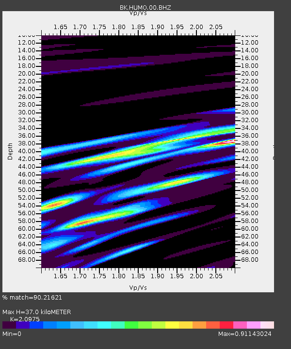
| Estimated Moho Depth: |
37.0 km |
| Estimated Crust Vp/Vs: |
2.10 |
| Assumed Crust Vp: |
6.522 km/s |
| Estimated Crust Vs: |
3.109 km/s |
| Estimated Crust Poisson's Ratio: |
0.35 |
|
| Radial Match: |
90.21621 % |
| Radial Bump: |
400 |
| Transverse Match: |
66.35816 % |
| Transverse Bump: |
400 |
| SOD ConfigId: |
478790 |
| Insert Time: |
2013-02-23 00:35:23.125 +0000 |
| GWidth: |
2.5 |
| Max Bumps: |
400 |
| Tol: |
0.001 |
|

Signal To Noise
| Channel | StoN | STA | LTA |
| BK:HUMO:00:BHZ:20120930T16:40:40.295012Z | 5.7332425 | 1.5339285E-6 | 2.675499E-7 |
| BK:HUMO:00:BHN:20120930T16:40:40.295012Z | 3.5113034 | 6.9561753E-7 | 1.9810807E-7 |
| BK:HUMO:00:BHE:20120930T16:40:40.295012Z | 2.7790084 | 6.2277894E-7 | 2.2410116E-7 |
| Arrivals |
| Ps | 6.5 SECOND |
| PpPs | 17 SECOND |
| PsPs/PpSs | 23 SECOND |


