You are here: Home > Network List > CI - Caltech Regional Seismic Network Stations List
> Station LGU LGU, Camarillo, CA, USA > Earthquake Result Viewer
LGU LGU, Camarillo, CA, USA - Earthquake Result Viewer
| Earthquake location: |
Colombia |
| Earthquake latitude/longitude: |
1.9/-76.4 |
| Earthquake time(UTC): |
2012/09/30 (274) 16:31:35 GMT |
| Earthquake Depth: |
170 km |
| Earthquake Magnitude: |
7.0 MB, 7.3 MW, 7.2 MW |
| Earthquake Catalog/Contributor: |
WHDF/NEIC |
|
| Network: |
CI Caltech Regional Seismic Network |
| Station: |
LGU LGU, Camarillo, CA, USA |
| Lat/Lon: |
34.11 N/119.07 W |
| Elevation: |
416 m |
|
| Distance: |
51.1 deg |
| Az: |
313.685 deg |
| Baz: |
119.418 deg |
| Ray Param: |
0.06703632 |
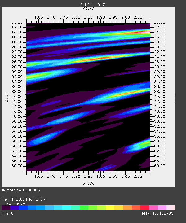
| Estimated Moho Depth: |
13.5 km |
| Estimated Crust Vp/Vs: |
2.10 |
| Assumed Crust Vp: |
6.1 km/s |
| Estimated Crust Vs: |
2.908 km/s |
| Estimated Crust Poisson's Ratio: |
0.35 |
|
| Radial Match: |
95.88065 % |
| Radial Bump: |
328 |
| Transverse Match: |
88.703606 % |
| Transverse Bump: |
400 |
| SOD ConfigId: |
478790 |
| Insert Time: |
2013-02-23 00:39:29.890 +0000 |
| GWidth: |
2.5 |
| Max Bumps: |
400 |
| Tol: |
0.001 |
|
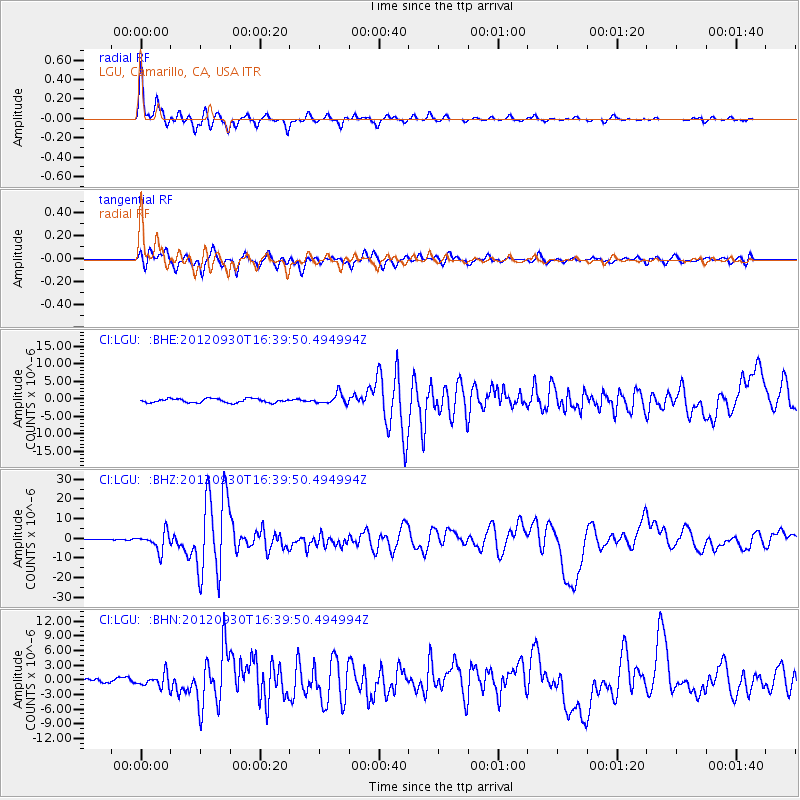
Signal To Noise
| Channel | StoN | STA | LTA |
| CI:LGU: :BHZ:20120930T16:39:50.494994Z | 11.174002 | 4.6377977E-6 | 4.1505254E-7 |
| CI:LGU: :BHN:20120930T16:39:50.494994Z | 4.091432 | 1.3249839E-6 | 3.2384358E-7 |
| CI:LGU: :BHE:20120930T16:39:50.494994Z | 2.6198895 | 1.4792203E-6 | 5.646117E-7 |
| Arrivals |
| Ps | 2.5 SECOND |
| PpPs | 6.6 SECOND |
| PsPs/PpSs | 9.1 SECOND |


