You are here: Home > Network List > CI - Caltech Regional Seismic Network Stations List
> Station EDW2 EDW2, Mojave, CA, USA > Earthquake Result Viewer
EDW2 EDW2, Mojave, CA, USA - Earthquake Result Viewer

| Earthquake location: |
Colombia |
| Earthquake latitude/longitude: |
1.9/-76.4 |
| Earthquake time(UTC): |
2012/09/30 (274) 16:31:35 GMT |
| Earthquake Depth: |
170 km |
| Earthquake Magnitude: |
7.0 MB, 7.3 MW, 7.2 MW |
| Earthquake Catalog/Contributor: |
WHDF/NEIC |
|
| Network: |
CI Caltech Regional Seismic Network |
| Station: |
EDW2 EDW2, Mojave, CA, USA |
| Lat/Lon: |
34.88 N/117.99 W |
| Elevation: |
772 m |
|
| Distance: |
50.7 deg |
| Az: |
315.118 deg |
| Baz: |
120.925 deg |
| Ray Param: |
0.06728447 |
| Estimated Moho Depth: |
32.25 km |
| Estimated Crust Vp/Vs: |
1.61 |
| Assumed Crust Vp: |
6.276 km/s |
| Estimated Crust Vs: |
3.898 km/s |
| Estimated Crust Poisson's Ratio: |
0.19 |
|
| Radial Match: |
96.38275 % |
| Radial Bump: |
341 |
| Transverse Match: |
89.914024 % |
| Transverse Bump: |
400 |
| SOD ConfigId: |
478790 |
| Insert Time: |
2013-02-23 00:41:07.693 +0000 |
| GWidth: |
2.5 |
| Max Bumps: |
400 |
| Tol: |
0.001 |
|
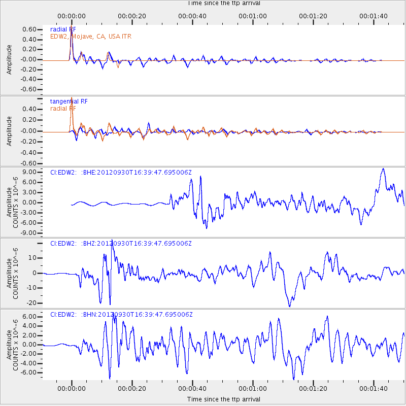
Signal To Noise
| Channel | StoN | STA | LTA |
| CI:EDW2: :BHZ:20120930T16:39:47.695006Z | 6.4045897 | 2.7852088E-6 | 4.3487702E-7 |
| CI:EDW2: :BHN:20120930T16:39:47.695006Z | 1.5098702 | 7.230333E-7 | 4.788712E-7 |
| CI:EDW2: :BHE:20120930T16:39:47.695006Z | 3.0028005 | 9.320257E-7 | 3.1038547E-7 |
| Arrivals |
| Ps | 3.3 SECOND |
| PpPs | 13 SECOND |
| PsPs/PpSs | 16 SECOND |


