You are here: Home > Network List > GT - Global Telemetered Seismograph Network (USAF/USGS) Stations List
> Station PLCA Paso Flores, Argentina > Earthquake Result Viewer
PLCA Paso Flores, Argentina - Earthquake Result Viewer
| Earthquake location: |
Colombia |
| Earthquake latitude/longitude: |
1.9/-76.4 |
| Earthquake time(UTC): |
2012/09/30 (274) 16:31:35 GMT |
| Earthquake Depth: |
170 km |
| Earthquake Magnitude: |
7.0 MB, 7.3 MW, 7.2 MW |
| Earthquake Catalog/Contributor: |
WHDF/NEIC |
|
| Network: |
GT Global Telemetered Seismograph Network (USAF/USGS) |
| Station: |
PLCA Paso Flores, Argentina |
| Lat/Lon: |
40.73 S/70.55 W |
| Elevation: |
1050 m |
|
| Distance: |
42.8 deg |
| Az: |
173.496 deg |
| Baz: |
351.433 deg |
| Ray Param: |
0.07230841 |
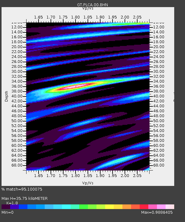
| Estimated Moho Depth: |
35.75 km |
| Estimated Crust Vp/Vs: |
1.80 |
| Assumed Crust Vp: |
6.597 km/s |
| Estimated Crust Vs: |
3.665 km/s |
| Estimated Crust Poisson's Ratio: |
0.28 |
|
| Radial Match: |
95.100075 % |
| Radial Bump: |
288 |
| Transverse Match: |
86.65099 % |
| Transverse Bump: |
400 |
| SOD ConfigId: |
478790 |
| Insert Time: |
2013-02-23 00:43:18.722 +0000 |
| GWidth: |
2.5 |
| Max Bumps: |
400 |
| Tol: |
0.001 |
|
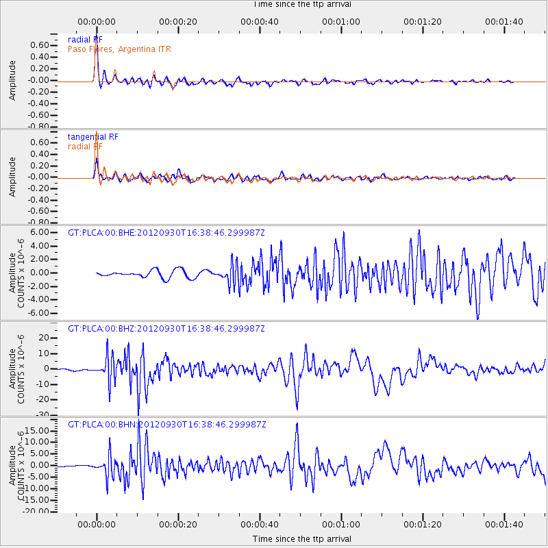
Signal To Noise
| Channel | StoN | STA | LTA |
| GT:PLCA:00:BHZ:20120930T16:38:46.299987Z | 17.949543 | 7.8560615E-6 | 4.3767477E-7 |
| GT:PLCA:00:BHN:20120930T16:38:46.299987Z | 13.498351 | 4.421704E-6 | 3.2757364E-7 |
| GT:PLCA:00:BHE:20120930T16:38:46.299987Z | 2.3370876 | 1.307113E-6 | 5.592914E-7 |
| Arrivals |
| Ps | 4.6 SECOND |
| PpPs | 14 SECOND |
| PsPs/PpSs | 19 SECOND |


