You are here: Home > Network List > IW - Intermountain West Stations List
> Station IMW Indian Meadow, Wyoming, USA > Earthquake Result Viewer
IMW Indian Meadow, Wyoming, USA - Earthquake Result Viewer
| Earthquake location: |
Colombia |
| Earthquake latitude/longitude: |
1.9/-76.4 |
| Earthquake time(UTC): |
2012/09/30 (274) 16:31:35 GMT |
| Earthquake Depth: |
170 km |
| Earthquake Magnitude: |
7.0 MB, 7.3 MW, 7.2 MW |
| Earthquake Catalog/Contributor: |
WHDF/NEIC |
|
| Network: |
IW Intermountain West |
| Station: |
IMW Indian Meadow, Wyoming, USA |
| Lat/Lon: |
43.90 N/110.94 W |
| Elevation: |
2646 m |
|
| Distance: |
51.8 deg |
| Az: |
328.544 deg |
| Baz: |
133.825 deg |
| Ray Param: |
0.066567056 |
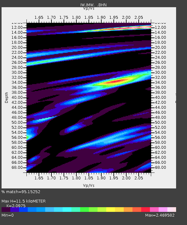
| Estimated Moho Depth: |
11.5 km |
| Estimated Crust Vp/Vs: |
2.10 |
| Assumed Crust Vp: |
6.207 km/s |
| Estimated Crust Vs: |
2.959 km/s |
| Estimated Crust Poisson's Ratio: |
0.35 |
|
| Radial Match: |
95.15252 % |
| Radial Bump: |
400 |
| Transverse Match: |
80.043816 % |
| Transverse Bump: |
400 |
| SOD ConfigId: |
478790 |
| Insert Time: |
2013-02-23 00:44:24.280 +0000 |
| GWidth: |
2.5 |
| Max Bumps: |
400 |
| Tol: |
0.001 |
|

Signal To Noise
| Channel | StoN | STA | LTA |
| IW:IMW: :BHZ:20120930T16:39:55.954985Z | 21.517765 | 2.285043E-6 | 1.0619332E-7 |
| IW:IMW: :BHN:20120930T16:39:55.954985Z | 24.054338 | 1.2312129E-6 | 5.118465E-8 |
| IW:IMW: :BHE:20120930T16:39:55.954985Z | 10.43413 | 1.122703E-6 | 1.075991E-7 |
| Arrivals |
| Ps | 2.1 SECOND |
| PpPs | 5.5 SECOND |
| PsPs/PpSs | 7.6 SECOND |


