You are here: Home > Network List > G - GEOSCOPE Stations List
> Station WUS Wushi, Xinjiang Uygur, China > Earthquake Result Viewer
WUS Wushi, Xinjiang Uygur, China - Earthquake Result Viewer
| Earthquake location: |
Alaska Peninsula |
| Earthquake latitude/longitude: |
55.2/-160.5 |
| Earthquake time(UTC): |
1993/05/13 (133) 11:59:49 GMT |
| Earthquake Depth: |
32 km |
| Earthquake Magnitude: |
6.4 MB, 6.8 MS, 6.8 UNKNOWN |
| Earthquake Catalog/Contributor: |
WHDF/NEIC |
|
| Network: |
G GEOSCOPE |
| Station: |
WUS Wushi, Xinjiang Uygur, China |
| Lat/Lon: |
41.20 N/79.22 E |
| Elevation: |
1457 m |
|
| Distance: |
71.4 deg |
| Az: |
316.586 deg |
| Baz: |
31.495 deg |
| Ray Param: |
0.054304942 |
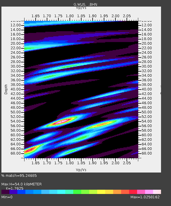
| Estimated Moho Depth: |
54.0 km |
| Estimated Crust Vp/Vs: |
1.76 |
| Assumed Crust Vp: |
6.353 km/s |
| Estimated Crust Vs: |
3.605 km/s |
| Estimated Crust Poisson's Ratio: |
0.26 |
|
| Radial Match: |
95.24685 % |
| Radial Bump: |
400 |
| Transverse Match: |
91.516014 % |
| Transverse Bump: |
400 |
| SOD ConfigId: |
16938 |
| Insert Time: |
2010-02-27 00:51:46.895 +0000 |
| GWidth: |
2.5 |
| Max Bumps: |
400 |
| Tol: |
0.001 |
|

Signal To Noise
| Channel | StoN | STA | LTA |
| G:WUS: :BHN:19930513T12:10:35.200Z | 29.916895 | 1.236094E-6 | 4.131759E-8 |
| G:WUS: :BHE:19930513T12:10:35.200Z | 19.8244 | 8.842398E-7 | 4.460361E-8 |
| G:WUS: :BHZ:19930513T12:10:35.200Z | 59.523254 | 3.79154E-6 | 6.3698465E-8 |
| Arrivals |
| Ps | 6.7 SECOND |
| PpPs | 23 SECOND |
| PsPs/PpSs | 29 SECOND |


