You are here: Home > Network List > G - GEOSCOPE Stations List
> Station WUS Wushi, Xinjiang Uygur, China > Earthquake Result Viewer
WUS Wushi, Xinjiang Uygur, China - Earthquake Result Viewer
| Earthquake location: |
Hokkaido, Japan Region |
| Earthquake latitude/longitude: |
43.0/144.2 |
| Earthquake time(UTC): |
1993/01/15 (015) 11:06:00 GMT |
| Earthquake Depth: |
100 km |
| Earthquake Magnitude: |
6.0 MB |
| Earthquake Catalog/Contributor: |
WHDF/NEIC |
|
| Network: |
G GEOSCOPE |
| Station: |
WUS Wushi, Xinjiang Uygur, China |
| Lat/Lon: |
41.20 N/79.22 E |
| Elevation: |
1457 m |
|
| Distance: |
47.2 deg |
| Az: |
291.157 deg |
| Baz: |
65.081 deg |
| Ray Param: |
0.069842204 |
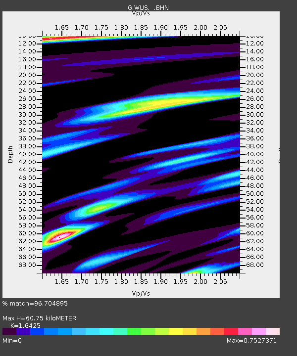
| Estimated Moho Depth: |
60.75 km |
| Estimated Crust Vp/Vs: |
1.64 |
| Assumed Crust Vp: |
6.353 km/s |
| Estimated Crust Vs: |
3.868 km/s |
| Estimated Crust Poisson's Ratio: |
0.21 |
|
| Radial Match: |
96.704895 % |
| Radial Bump: |
320 |
| Transverse Match: |
90.09537 % |
| Transverse Bump: |
400 |
| SOD ConfigId: |
16938 |
| Insert Time: |
2010-02-27 00:51:51.385 +0000 |
| GWidth: |
2.5 |
| Max Bumps: |
400 |
| Tol: |
0.001 |
|

Signal To Noise
| Channel | StoN | STA | LTA |
| G:WUS: :BHN:19930115T11:13:52.350006Z | 2.9711518 | 6.1123916E-7 | 2.0572465E-7 |
| G:WUS: :BHE:19930115T11:13:52.350006Z | 4.6428804 | 1.2739634E-6 | 2.7439074E-7 |
| G:WUS: :BHZ:19930115T11:13:52.350006Z | 4.050932 | 2.1485273E-6 | 5.303785E-7 |
| Arrivals |
| Ps | 6.6 SECOND |
| PpPs | 24 SECOND |
| PsPs/PpSs | 30 SECOND |


