You are here: Home > Network List > TA - USArray Transportable Network (new EarthScope stations) Stations List
> Station Y12C Blythe, CA, USA > Earthquake Result Viewer
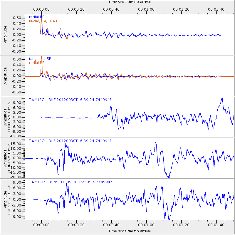
Y12C Blythe, CA, USA - Earthquake Result Viewer
| Earthquake location: |
Colombia |
| Earthquake latitude/longitude: |
1.9/-76.4 |
| Earthquake time(UTC): |
2012/09/30 (274) 16:31:35 GMT |
| Earthquake Depth: |
170 km |
| Earthquake Magnitude: |
7.0 MB, 7.3 MW, 7.2 MW |
| Earthquake Catalog/Contributor: |
WHDF/NEIC |
|
| Network: |
TA USArray Transportable Network (new EarthScope stations) |
| Station: |
Y12C Blythe, CA, USA |
| Lat/Lon: |
33.75 N/114.52 W |
| Elevation: |
196 m |
|
| Distance: |
47.7 deg |
| Az: |
315.875 deg |
| Baz: |
123.368 deg |
| Ray Param: |
0.06922505 |
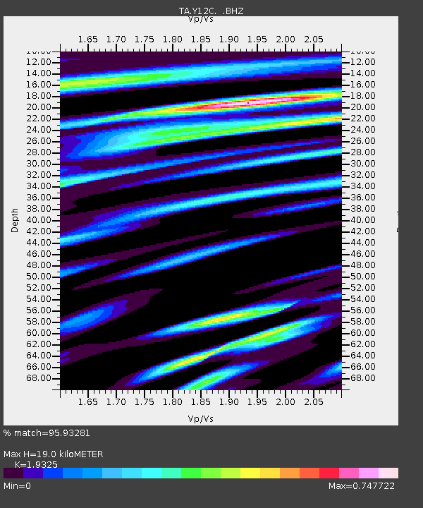
| Estimated Moho Depth: |
19.0 km |
| Estimated Crust Vp/Vs: |
1.93 |
| Assumed Crust Vp: |
6.155 km/s |
| Estimated Crust Vs: |
3.185 km/s |
| Estimated Crust Poisson's Ratio: |
0.32 |
|
| Radial Match: |
95.93281 % |
| Radial Bump: |
400 |
| Transverse Match: |
89.239395 % |
| Transverse Bump: |
400 |
| SOD ConfigId: |
478790 |
| Insert Time: |
2013-02-23 00:50:33.715 +0000 |
| GWidth: |
2.5 |
| Max Bumps: |
400 |
| Tol: |
0.001 |
|
Signal To Noise
| Channel | StoN | STA | LTA |
| TA:Y12C: :BHZ:20120930T16:39:24.744994Z | 10.884592 | 2.1266337E-6 | 1.9538018E-7 |
| TA:Y12C: :BHN:20120930T16:39:24.744994Z | 3.8481596 | 7.525832E-7 | 1.9556965E-7 |
| TA:Y12C: :BHE:20120930T16:39:24.744994Z | 4.905335 | 7.154153E-7 | 1.4584433E-7 |
| Arrivals |
| Ps | 3.0 SECOND |
| PpPs | 8.6 SECOND |
| PsPs/PpSs | 12 SECOND |


