You are here: Home > Network List > G - GEOSCOPE Stations List
> Station WUS Wushi, Xinjiang Uygur, China > Earthquake Result Viewer
WUS Wushi, Xinjiang Uygur, China - Earthquake Result Viewer
| Earthquake location: |
Sea Of Japan |
| Earthquake latitude/longitude: |
38.6/133.5 |
| Earthquake time(UTC): |
1993/01/19 (019) 14:39:26 GMT |
| Earthquake Depth: |
455 km |
| Earthquake Magnitude: |
6.0 MB |
| Earthquake Catalog/Contributor: |
WHDF/NEIC |
|
| Network: |
G GEOSCOPE |
| Station: |
WUS Wushi, Xinjiang Uygur, China |
| Lat/Lon: |
41.20 N/79.22 E |
| Elevation: |
1457 m |
|
| Distance: |
41.1 deg |
| Az: |
291.385 deg |
| Baz: |
75.126 deg |
| Ray Param: |
0.071863286 |
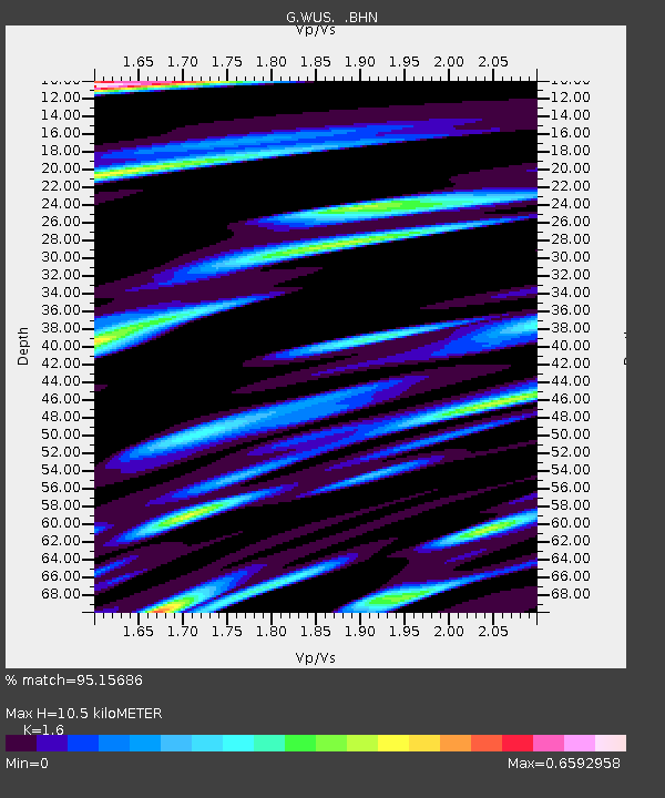
| Estimated Moho Depth: |
10.5 km |
| Estimated Crust Vp/Vs: |
1.60 |
| Assumed Crust Vp: |
6.353 km/s |
| Estimated Crust Vs: |
3.971 km/s |
| Estimated Crust Poisson's Ratio: |
0.18 |
|
| Radial Match: |
95.15686 % |
| Radial Bump: |
319 |
| Transverse Match: |
88.6675 % |
| Transverse Bump: |
400 |
| SOD ConfigId: |
16938 |
| Insert Time: |
2010-02-27 00:51:55.017 +0000 |
| GWidth: |
2.5 |
| Max Bumps: |
400 |
| Tol: |
0.001 |
|

Signal To Noise
| Channel | StoN | STA | LTA |
| G:WUS: :BHN:19930119T14:45:59.050006Z | 31.17869 | 2.2826355E-6 | 7.3211396E-8 |
| G:WUS: :BHE:19930119T14:45:59.050006Z | 48.306416 | 4.8611914E-6 | 1.0063242E-7 |
| G:WUS: :BHZ:19930119T14:45:59.050006Z | 154.47343 | 1.0837862E-5 | 7.0160034E-8 |
| Arrivals |
| Ps | 1.1 SECOND |
| PpPs | 4.0 SECOND |
| PsPs/PpSs | 5.1 SECOND |


