You are here: Home > Network List > AK - Alaska Regional Network Stations List
> Station MDM Murphy Dome > Earthquake Result Viewer
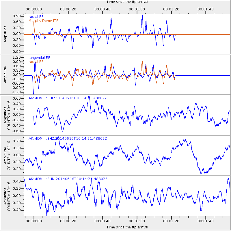
MDM Murphy Dome - Earthquake Result Viewer
*The percent match for this event was below the threshold and hence no stack was calculated.
| Earthquake location: |
Mexico-Guatemala Border Region |
| Earthquake latitude/longitude: |
15.3/-91.9 |
| Earthquake time(UTC): |
2014/06/16 (167) 10:04:30 GMT |
| Earthquake Depth: |
10 km |
| Earthquake Magnitude: |
5.0 MW |
| Earthquake Catalog/Contributor: |
ISC/ISC |
|
| Network: |
AK Alaska Regional Network |
| Station: |
MDM Murphy Dome |
| Lat/Lon: |
64.96 N/148.23 W |
| Elevation: |
634 m |
|
| Distance: |
62.3 deg |
| Az: |
336.427 deg |
| Baz: |
114.936 deg |
| Ray Param: |
$rayparam |
*The percent match for this event was below the threshold and hence was not used in the summary stack. |
|
| Radial Match: |
74.26335 % |
| Radial Bump: |
400 |
| Transverse Match: |
53.655163 % |
| Transverse Bump: |
400 |
| SOD ConfigId: |
3390531 |
| Insert Time: |
2019-04-12 07:19:57.912 +0000 |
| GWidth: |
2.5 |
| Max Bumps: |
400 |
| Tol: |
0.001 |
|
Signal To Noise
| Channel | StoN | STA | LTA |
| AK:MDM: :BHZ:20140616T10:14:21.48802Z | 1.5616373 | 1.2674003E-7 | 8.115843E-8 |
| AK:MDM: :BHN:20140616T10:14:21.48802Z | 0.5941318 | 1.7899882E-7 | 3.0127796E-7 |
| AK:MDM: :BHE:20140616T10:14:21.48802Z | 2.2669833 | 4.7210602E-7 | 2.0825298E-7 |
| Arrivals |
| Ps | |
| PpPs | |
| PsPs/PpSs | |


