You are here: Home > Network List > G - GEOSCOPE Stations List
> Station WUS Wushi, Xinjiang Uygur, China > Earthquake Result Viewer
WUS Wushi, Xinjiang Uygur, China - Earthquake Result Viewer

| Earthquake location: |
Banda Sea |
| Earthquake latitude/longitude: |
-7.2/128.6 |
| Earthquake time(UTC): |
1993/01/20 (020) 17:31:15 GMT |
| Earthquake Depth: |
33 km |
| Earthquake Magnitude: |
6.0 MB, 6.3 MS |
| Earthquake Catalog/Contributor: |
WHDF/NEIC |
|
| Network: |
G GEOSCOPE |
| Station: |
WUS Wushi, Xinjiang Uygur, China |
| Lat/Lon: |
41.20 N/79.22 E |
| Elevation: |
1457 m |
|
| Distance: |
66.1 deg |
| Az: |
321.205 deg |
| Baz: |
124.538 deg |
| Ray Param: |
0.057793636 |
| Estimated Moho Depth: |
48.75 km |
| Estimated Crust Vp/Vs: |
1.79 |
| Assumed Crust Vp: |
6.353 km/s |
| Estimated Crust Vs: |
3.549 km/s |
| Estimated Crust Poisson's Ratio: |
0.27 |
|
| Radial Match: |
94.786 % |
| Radial Bump: |
400 |
| Transverse Match: |
91.26045 % |
| Transverse Bump: |
400 |
| SOD ConfigId: |
16938 |
| Insert Time: |
2010-02-27 00:51:59.900 +0000 |
| GWidth: |
2.5 |
| Max Bumps: |
400 |
| Tol: |
0.001 |
|
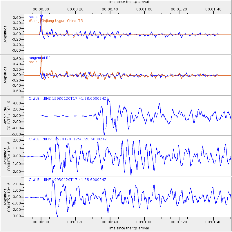
Signal To Noise
| Channel | StoN | STA | LTA |
| G:WUS: :BHN:19930120T17:41:28.600024Z | 4.6264906 | 2.578034E-7 | 5.5723312E-8 |
| G:WUS: :BHE:19930120T17:41:28.600024Z | 4.344319 | 2.4911418E-7 | 5.734252E-8 |
| G:WUS: :BHZ:19930120T17:41:28.600024Z | 9.602189 | 7.9331795E-7 | 8.261845E-8 |
| Arrivals |
| Ps | 6.3 SECOND |
| PpPs | 21 SECOND |
| PsPs/PpSs | 27 SECOND |


