You are here: Home > Network List > TA - USArray Transportable Network (new EarthScope stations) Stations List
> Station O03D Paynes Creek, CA, USA > Earthquake Result Viewer
O03D Paynes Creek, CA, USA - Earthquake Result Viewer
| Earthquake location: |
Colombia |
| Earthquake latitude/longitude: |
1.9/-76.4 |
| Earthquake time(UTC): |
2012/09/30 (274) 16:31:35 GMT |
| Earthquake Depth: |
170 km |
| Earthquake Magnitude: |
7.0 MB, 7.3 MW, 7.2 MW |
| Earthquake Catalog/Contributor: |
WHDF/NEIC |
|
| Network: |
TA USArray Transportable Network (new EarthScope stations) |
| Station: |
O03D Paynes Creek, CA, USA |
| Lat/Lon: |
40.29 N/121.80 W |
| Elevation: |
968 m |
|
| Distance: |
56.1 deg |
| Az: |
318.953 deg |
| Baz: |
120.899 deg |
| Ray Param: |
0.06380957 |
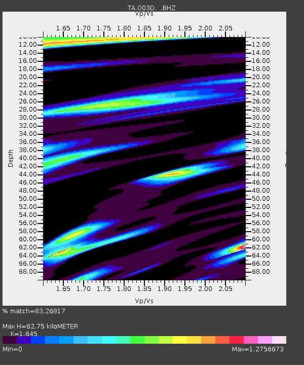
| Estimated Moho Depth: |
62.75 km |
| Estimated Crust Vp/Vs: |
1.64 |
| Assumed Crust Vp: |
6.566 km/s |
| Estimated Crust Vs: |
3.992 km/s |
| Estimated Crust Poisson's Ratio: |
0.21 |
|
| Radial Match: |
83.26817 % |
| Radial Bump: |
400 |
| Transverse Match: |
83.230484 % |
| Transverse Bump: |
400 |
| SOD ConfigId: |
478790 |
| Insert Time: |
2013-02-23 00:53:55.024 +0000 |
| GWidth: |
2.5 |
| Max Bumps: |
400 |
| Tol: |
0.001 |
|
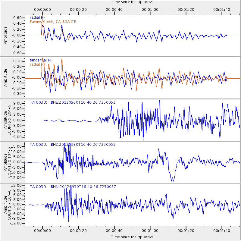
Signal To Noise
| Channel | StoN | STA | LTA |
| TA:O03D: :BHZ:20120930T16:40:26.725005Z | 9.645404 | 2.4822991E-6 | 2.5735562E-7 |
| TA:O03D: :BHN:20120930T16:40:26.725005Z | 5.8021894 | 1.0524619E-6 | 1.8139048E-7 |
| TA:O03D: :BHE:20120930T16:40:26.725005Z | 2.6374977 | 7.400306E-7 | 2.805806E-7 |
| Arrivals |
| Ps | 6.5 SECOND |
| PpPs | 24 SECOND |
| PsPs/PpSs | 30 SECOND |


