You are here: Home > Network List > G - GEOSCOPE Stations List
> Station WUS Wushi, Xinjiang Uygur, China > Earthquake Result Viewer
WUS Wushi, Xinjiang Uygur, China - Earthquake Result Viewer
| Earthquake location: |
North Of Halmahera, Indonesia |
| Earthquake latitude/longitude: |
4.0/128.2 |
| Earthquake time(UTC): |
1993/04/19 (109) 21:01:54 GMT |
| Earthquake Depth: |
70 km |
| Earthquake Magnitude: |
6.1 MB, 6.7 MS, 6.8 UNKNOWN |
| Earthquake Catalog/Contributor: |
WHDF/NEIC |
|
| Network: |
G GEOSCOPE |
| Station: |
WUS Wushi, Xinjiang Uygur, China |
| Lat/Lon: |
41.20 N/79.22 E |
| Elevation: |
1457 m |
|
| Distance: |
57.3 deg |
| Az: |
317.448 deg |
| Baz: |
116.62 deg |
| Ray Param: |
0.063375466 |
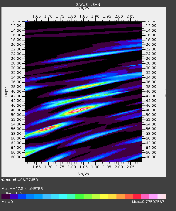
| Estimated Moho Depth: |
47.5 km |
| Estimated Crust Vp/Vs: |
1.84 |
| Assumed Crust Vp: |
6.353 km/s |
| Estimated Crust Vs: |
3.462 km/s |
| Estimated Crust Poisson's Ratio: |
0.29 |
|
| Radial Match: |
96.77653 % |
| Radial Bump: |
400 |
| Transverse Match: |
85.8834 % |
| Transverse Bump: |
400 |
| SOD ConfigId: |
16938 |
| Insert Time: |
2010-02-27 00:52:11.583 +0000 |
| GWidth: |
2.5 |
| Max Bumps: |
400 |
| Tol: |
0.001 |
|
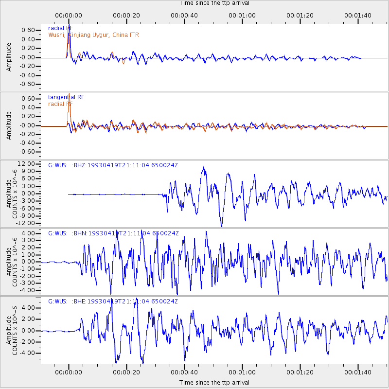
Signal To Noise
| Channel | StoN | STA | LTA |
| G:WUS: :BHN:19930419T21:11:04.650024Z | 6.7265897 | 5.4171977E-7 | 8.0534086E-8 |
| G:WUS: :BHE:19930419T21:11:04.650024Z | 9.729469 | 7.198184E-7 | 7.3983315E-8 |
| G:WUS: :BHZ:19930419T21:11:04.650024Z | 20.869387 | 1.7784247E-6 | 8.521691E-8 |
| Arrivals |
| Ps | 6.5 SECOND |
| PpPs | 20 SECOND |
| PsPs/PpSs | 27 SECOND |


