You are here: Home > Network List > TA - USArray Transportable Network (new EarthScope stations) Stations List
> Station 241A Mo Tay, Goldonna, LA, USA > Earthquake Result Viewer
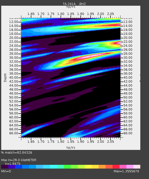
241A Mo Tay, Goldonna, LA, USA - Earthquake Result Viewer
| Earthquake location: |
Colombia |
| Earthquake latitude/longitude: |
1.9/-76.4 |
| Earthquake time(UTC): |
2012/09/30 (274) 16:31:35 GMT |
| Earthquake Depth: |
170 km |
| Earthquake Magnitude: |
7.0 MB, 7.3 MW, 7.2 MW |
| Earthquake Catalog/Contributor: |
WHDF/NEIC |
|
| Network: |
TA USArray Transportable Network (new EarthScope stations) |
| Station: |
241A Mo Tay, Goldonna, LA, USA |
| Lat/Lon: |
32.02 N/92.92 W |
| Elevation: |
59 m |
|
| Distance: |
33.8 deg |
| Az: |
334.175 deg |
| Baz: |
149.166 deg |
| Ray Param: |
0.077503294 |
| Estimated Moho Depth: |
29.0 km |
| Estimated Crust Vp/Vs: |
1.95 |
| Assumed Crust Vp: |
6.245 km/s |
| Estimated Crust Vs: |
3.207 km/s |
| Estimated Crust Poisson's Ratio: |
0.32 |
|
| Radial Match: |
92.84326 % |
| Radial Bump: |
389 |
| Transverse Match: |
70.58235 % |
| Transverse Bump: |
400 |
| SOD ConfigId: |
478790 |
| Insert Time: |
2013-02-23 00:57:01.334 +0000 |
| GWidth: |
2.5 |
| Max Bumps: |
400 |
| Tol: |
0.001 |
|

Signal To Noise
| Channel | StoN | STA | LTA |
| TA:241A: :BHZ:20120930T16:37:31.075011Z | 8.853947 | 2.1361047E-6 | 2.4126018E-7 |
| TA:241A: :BHN:20120930T16:37:31.075011Z | 2.5046809 | 8.839028E-7 | 3.5290037E-7 |
| TA:241A: :BHE:20120930T16:37:31.075011Z | 3.754368 | 9.1759193E-7 | 2.444065E-7 |
| Arrivals |
| Ps | 4.7 SECOND |
| PpPs | 13 SECOND |
| PsPs/PpSs | 18 SECOND |


