You are here: Home > Network List > G - GEOSCOPE Stations List
> Station WUS Wushi, Xinjiang Uygur, China > Earthquake Result Viewer
WUS Wushi, Xinjiang Uygur, China - Earthquake Result Viewer
| Earthquake location: |
Andreanof Islands, Aleutian Is. |
| Earthquake latitude/longitude: |
51.3/-178.7 |
| Earthquake time(UTC): |
1993/05/15 (135) 21:52:25 GMT |
| Earthquake Depth: |
33 km |
| Earthquake Magnitude: |
6.2 MB, 6.5 MS, 6.3 UNKNOWN, 6.1 ML |
| Earthquake Catalog/Contributor: |
WHDF/NEIC |
|
| Network: |
G GEOSCOPE |
| Station: |
WUS Wushi, Xinjiang Uygur, China |
| Lat/Lon: |
41.20 N/79.22 E |
| Elevation: |
1457 m |
|
| Distance: |
65.7 deg |
| Az: |
305.947 deg |
| Baz: |
42.293 deg |
| Ray Param: |
0.05805204 |
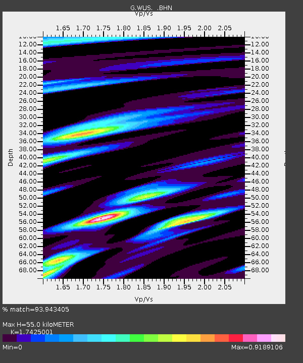
| Estimated Moho Depth: |
55.0 km |
| Estimated Crust Vp/Vs: |
1.74 |
| Assumed Crust Vp: |
6.353 km/s |
| Estimated Crust Vs: |
3.646 km/s |
| Estimated Crust Poisson's Ratio: |
0.25 |
|
| Radial Match: |
93.943405 % |
| Radial Bump: |
400 |
| Transverse Match: |
95.215485 % |
| Transverse Bump: |
400 |
| SOD ConfigId: |
16938 |
| Insert Time: |
2010-02-27 00:52:16.040 +0000 |
| GWidth: |
2.5 |
| Max Bumps: |
400 |
| Tol: |
0.001 |
|

Signal To Noise
| Channel | StoN | STA | LTA |
| G:WUS: :BHN:19930515T22:02:35.748999Z | 9.032274 | 7.6184534E-7 | 8.434701E-8 |
| G:WUS: :BHE:19930515T22:02:35.748999Z | 15.938475 | 6.8488464E-7 | 4.2970527E-8 |
| G:WUS: :BHZ:19930515T22:02:35.748999Z | 20.721422 | 2.1011915E-6 | 1.01401895E-7 |
| Arrivals |
| Ps | 6.7 SECOND |
| PpPs | 23 SECOND |
| PsPs/PpSs | 29 SECOND |


