You are here: Home > Network List > IU - Global Seismograph Network (GSN - IRIS/USGS) Stations List
> Station RSSD Black Hills, South Dakota, USA > Earthquake Result Viewer
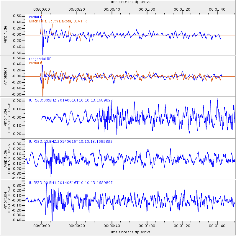
RSSD Black Hills, South Dakota, USA - Earthquake Result Viewer
*The percent match for this event was below the threshold and hence no stack was calculated.
| Earthquake location: |
Mexico-Guatemala Border Region |
| Earthquake latitude/longitude: |
15.3/-91.9 |
| Earthquake time(UTC): |
2014/06/16 (167) 10:04:30 GMT |
| Earthquake Depth: |
10 km |
| Earthquake Magnitude: |
5.0 MW |
| Earthquake Catalog/Contributor: |
ISC/ISC |
|
| Network: |
IU Global Seismograph Network (GSN - IRIS/USGS) |
| Station: |
RSSD Black Hills, South Dakota, USA |
| Lat/Lon: |
44.12 N/104.04 W |
| Elevation: |
2090 m |
|
| Distance: |
30.5 deg |
| Az: |
342.723 deg |
| Baz: |
156.55 deg |
| Ray Param: |
$rayparam |
*The percent match for this event was below the threshold and hence was not used in the summary stack. |
|
| Radial Match: |
51.772972 % |
| Radial Bump: |
400 |
| Transverse Match: |
52.366665 % |
| Transverse Bump: |
400 |
| SOD ConfigId: |
3390531 |
| Insert Time: |
2019-04-12 07:22:07.382 +0000 |
| GWidth: |
2.5 |
| Max Bumps: |
400 |
| Tol: |
0.001 |
|
Signal To Noise
| Channel | StoN | STA | LTA |
| IU:RSSD:00:BHZ:20140616T10:10:13.168989Z | 1.7939554 | 1.088286E-7 | 6.066405E-8 |
| IU:RSSD:00:BH1:20140616T10:10:13.168989Z | 2.1127534 | 1.0895207E-7 | 5.1568758E-8 |
| IU:RSSD:00:BH2:20140616T10:10:13.168989Z | 1.3667707 | 5.2738276E-8 | 3.8586045E-8 |
| Arrivals |
| Ps | |
| PpPs | |
| PsPs/PpSs | |


