You are here: Home > Network List > IU - Global Seismograph Network (GSN - IRIS/USGS) Stations List
> Station XMAS Kiritimati Island, Republic of Kiribati > Earthquake Result Viewer
XMAS Kiritimati Island, Republic of Kiribati - Earthquake Result Viewer
*The percent match for this event was below the threshold and hence no stack was calculated.
| Earthquake location: |
Mexico-Guatemala Border Region |
| Earthquake latitude/longitude: |
15.3/-91.9 |
| Earthquake time(UTC): |
2014/06/16 (167) 10:04:30 GMT |
| Earthquake Depth: |
10 km |
| Earthquake Magnitude: |
5.0 MW |
| Earthquake Catalog/Contributor: |
ISC/ISC |
|
| Network: |
IU Global Seismograph Network (GSN - IRIS/USGS) |
| Station: |
XMAS Kiritimati Island, Republic of Kiribati |
| Lat/Lon: |
2.04 N/157.45 W |
| Elevation: |
20 m |
|
| Distance: |
65.8 deg |
| Az: |
265.322 deg |
| Baz: |
74.245 deg |
| Ray Param: |
$rayparam |
*The percent match for this event was below the threshold and hence was not used in the summary stack. |
|
| Radial Match: |
45.97758 % |
| Radial Bump: |
400 |
| Transverse Match: |
60.490322 % |
| Transverse Bump: |
373 |
| SOD ConfigId: |
3390531 |
| Insert Time: |
2019-04-12 07:22:08.726 +0000 |
| GWidth: |
2.5 |
| Max Bumps: |
400 |
| Tol: |
0.001 |
|
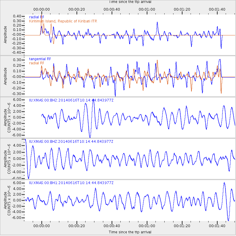
Signal To Noise
| Channel | StoN | STA | LTA |
| IU:XMAS:00:BHZ:20140616T10:14:44.843977Z | 0.5759347 | 1.3841315E-6 | 2.4032784E-6 |
| IU:XMAS:00:BH1:20140616T10:14:44.843977Z | 0.6447559 | 1.183575E-6 | 1.8356947E-6 |
| IU:XMAS:00:BH2:20140616T10:14:44.843977Z | 1.9141052 | 3.2477612E-6 | 1.6967517E-6 |
| Arrivals |
| Ps | |
| PpPs | |
| PsPs/PpSs | |


