You are here: Home > Network List > TA - USArray Transportable Network (new EarthScope stations) Stations List
> Station 146A Union, MS, USA > Earthquake Result Viewer
146A Union, MS, USA - Earthquake Result Viewer
| Earthquake location: |
Colombia |
| Earthquake latitude/longitude: |
1.9/-76.4 |
| Earthquake time(UTC): |
2012/09/30 (274) 16:31:35 GMT |
| Earthquake Depth: |
170 km |
| Earthquake Magnitude: |
7.0 MB, 7.3 MW, 7.2 MW |
| Earthquake Catalog/Contributor: |
WHDF/NEIC |
|
| Network: |
TA USArray Transportable Network (new EarthScope stations) |
| Station: |
146A Union, MS, USA |
| Lat/Lon: |
32.64 N/89.06 W |
| Elevation: |
164 m |
|
| Distance: |
32.8 deg |
| Az: |
339.981 deg |
| Baz: |
156.077 deg |
| Ray Param: |
0.077972 |
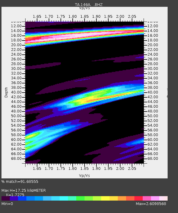
| Estimated Moho Depth: |
17.25 km |
| Estimated Crust Vp/Vs: |
1.73 |
| Assumed Crust Vp: |
6.201 km/s |
| Estimated Crust Vs: |
3.59 km/s |
| Estimated Crust Poisson's Ratio: |
0.25 |
|
| Radial Match: |
91.68555 % |
| Radial Bump: |
400 |
| Transverse Match: |
78.99247 % |
| Transverse Bump: |
400 |
| SOD ConfigId: |
478790 |
| Insert Time: |
2013-02-23 00:59:33.509 +0000 |
| GWidth: |
2.5 |
| Max Bumps: |
400 |
| Tol: |
0.001 |
|
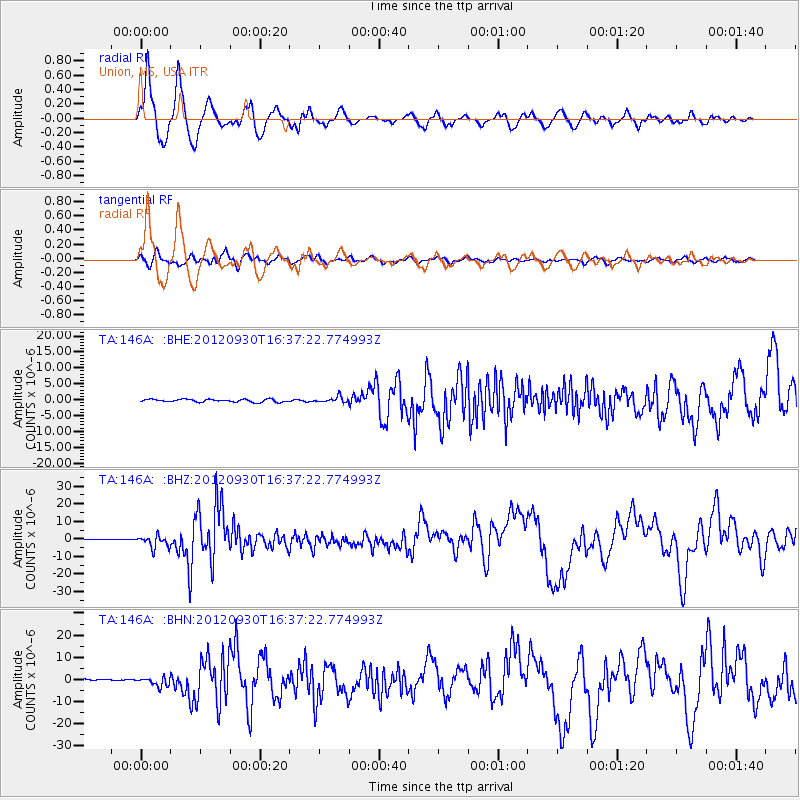
Signal To Noise
| Channel | StoN | STA | LTA |
| TA:146A: :BHZ:20120930T16:37:22.774993Z | 15.350874 | 3.4324182E-6 | 2.2359758E-7 |
| TA:146A: :BHN:20120930T16:37:22.774993Z | 5.315679 | 1.960754E-6 | 3.6886237E-7 |
| TA:146A: :BHE:20120930T16:37:22.774993Z | 2.0541995 | 8.9448525E-7 | 4.3544225E-7 |
| Arrivals |
| Ps | 2.2 SECOND |
| PpPs | 7.0 SECOND |
| PsPs/PpSs | 9.2 SECOND |


