You are here: Home > Network List > TA - USArray Transportable Network (new EarthScope stations) Stations List
> Station X41A Kaden, Bauxite, AR, USA > Earthquake Result Viewer
X41A Kaden, Bauxite, AR, USA - Earthquake Result Viewer
| Earthquake location: |
Colombia |
| Earthquake latitude/longitude: |
1.9/-76.4 |
| Earthquake time(UTC): |
2012/09/30 (274) 16:31:35 GMT |
| Earthquake Depth: |
170 km |
| Earthquake Magnitude: |
7.0 MB, 7.3 MW, 7.2 MW |
| Earthquake Catalog/Contributor: |
WHDF/NEIC |
|
| Network: |
TA USArray Transportable Network (new EarthScope stations) |
| Station: |
X41A Kaden, Bauxite, AR, USA |
| Lat/Lon: |
34.49 N/92.51 W |
| Elevation: |
102 m |
|
| Distance: |
35.7 deg |
| Az: |
336.832 deg |
| Baz: |
151.571 deg |
| Ray Param: |
0.07645626 |
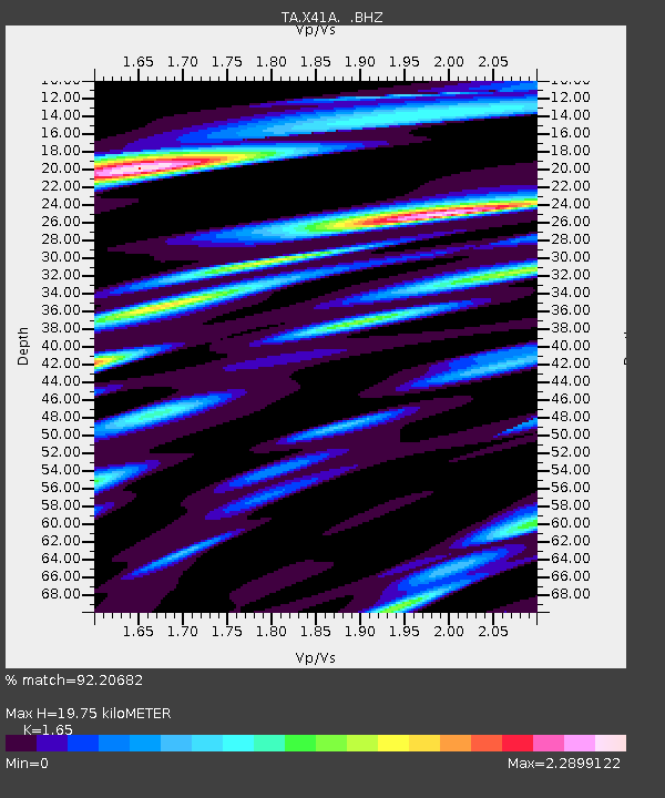
| Estimated Moho Depth: |
19.75 km |
| Estimated Crust Vp/Vs: |
1.65 |
| Assumed Crust Vp: |
6.498 km/s |
| Estimated Crust Vs: |
3.938 km/s |
| Estimated Crust Poisson's Ratio: |
0.21 |
|
| Radial Match: |
92.20682 % |
| Radial Bump: |
400 |
| Transverse Match: |
79.77457 % |
| Transverse Bump: |
400 |
| SOD ConfigId: |
478790 |
| Insert Time: |
2013-02-23 01:01:10.624 +0000 |
| GWidth: |
2.5 |
| Max Bumps: |
400 |
| Tol: |
0.001 |
|
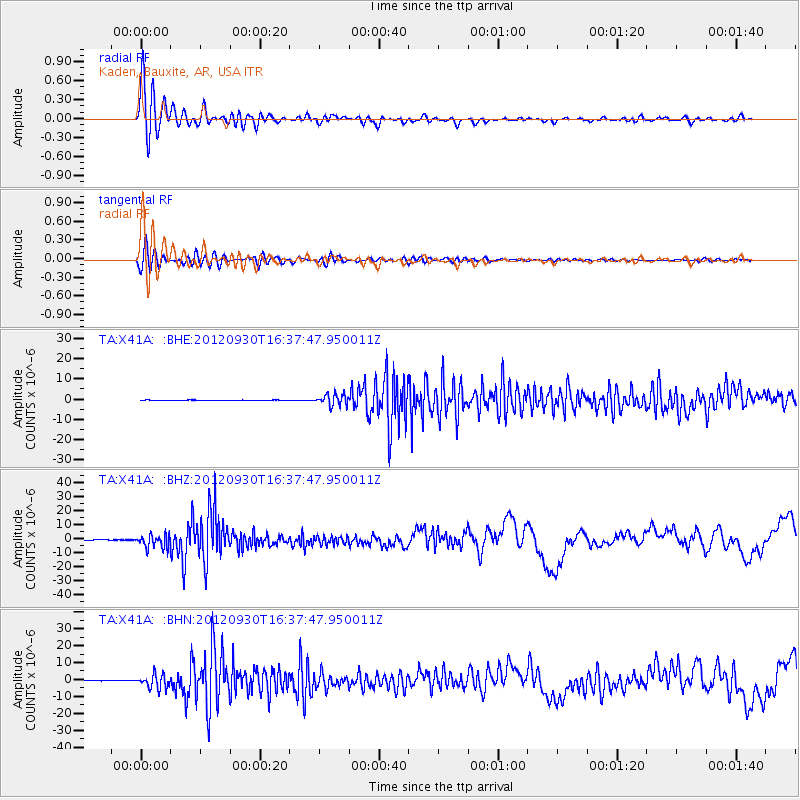
Signal To Noise
| Channel | StoN | STA | LTA |
| TA:X41A: :BHZ:20120930T16:37:47.950011Z | 34.85315 | 4.73653E-6 | 1.3589963E-7 |
| TA:X41A: :BHN:20120930T16:37:47.950011Z | 30.54396 | 4.077506E-6 | 1.3349633E-7 |
| TA:X41A: :BHE:20120930T16:37:47.950011Z | 27.827835 | 2.7582169E-6 | 9.9117194E-8 |
| Arrivals |
| Ps | 2.1 SECOND |
| PpPs | 7.4 SECOND |
| PsPs/PpSs | 9.6 SECOND |


