You are here: Home > Network List > TA - USArray Transportable Network (new EarthScope stations) Stations List
> Station T41A Mountain View, MO, USA > Earthquake Result Viewer
T41A Mountain View, MO, USA - Earthquake Result Viewer
| Earthquake location: |
Colombia |
| Earthquake latitude/longitude: |
1.9/-76.4 |
| Earthquake time(UTC): |
2012/09/30 (274) 16:31:35 GMT |
| Earthquake Depth: |
170 km |
| Earthquake Magnitude: |
7.0 MB, 7.3 MW, 7.2 MW |
| Earthquake Catalog/Contributor: |
WHDF/NEIC |
|
| Network: |
TA USArray Transportable Network (new EarthScope stations) |
| Station: |
T41A Mountain View, MO, USA |
| Lat/Lon: |
37.04 N/91.76 W |
| Elevation: |
366 m |
|
| Distance: |
37.7 deg |
| Az: |
339.676 deg |
| Baz: |
154.288 deg |
| Ray Param: |
0.0753461 |
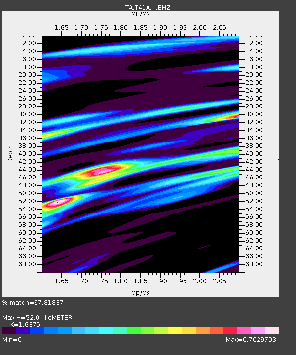
| Estimated Moho Depth: |
52.0 km |
| Estimated Crust Vp/Vs: |
1.64 |
| Assumed Crust Vp: |
6.53 km/s |
| Estimated Crust Vs: |
3.988 km/s |
| Estimated Crust Poisson's Ratio: |
0.20 |
|
| Radial Match: |
97.81837 % |
| Radial Bump: |
370 |
| Transverse Match: |
83.552284 % |
| Transverse Bump: |
400 |
| SOD ConfigId: |
478790 |
| Insert Time: |
2013-02-23 01:01:14.038 +0000 |
| GWidth: |
2.5 |
| Max Bumps: |
400 |
| Tol: |
0.001 |
|
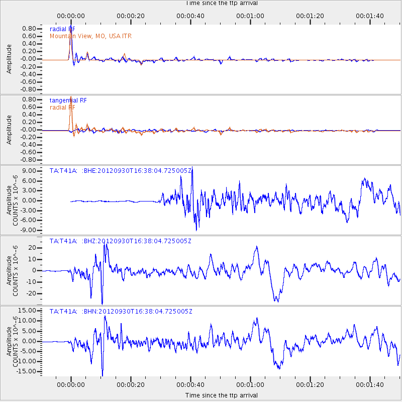
Signal To Noise
| Channel | StoN | STA | LTA |
| TA:T41A: :BHZ:20120930T16:38:04.725005Z | 25.801111 | 3.5279927E-6 | 1.3673802E-7 |
| TA:T41A: :BHN:20120930T16:38:04.725005Z | 19.805685 | 1.8841705E-6 | 9.513281E-8 |
| TA:T41A: :BHE:20120930T16:38:04.725005Z | 9.439339 | 1.055131E-6 | 1.1178018E-7 |
| Arrivals |
| Ps | 5.5 SECOND |
| PpPs | 19 SECOND |
| PsPs/PpSs | 25 SECOND |


