You are here: Home > Network List > TA - USArray Transportable Network (new EarthScope stations) Stations List
> Station W44A Shelby Farms Park, Memphis, TN, USA > Earthquake Result Viewer
W44A Shelby Farms Park, Memphis, TN, USA - Earthquake Result Viewer
| Earthquake location: |
Colombia |
| Earthquake latitude/longitude: |
1.9/-76.4 |
| Earthquake time(UTC): |
2012/09/30 (274) 16:31:35 GMT |
| Earthquake Depth: |
170 km |
| Earthquake Magnitude: |
7.0 MB, 7.3 MW, 7.2 MW |
| Earthquake Catalog/Contributor: |
WHDF/NEIC |
|
| Network: |
TA USArray Transportable Network (new EarthScope stations) |
| Station: |
W44A Shelby Farms Park, Memphis, TN, USA |
| Lat/Lon: |
35.14 N/89.82 W |
| Elevation: |
101 m |
|
| Distance: |
35.3 deg |
| Az: |
340.749 deg |
| Baz: |
156.293 deg |
| Ray Param: |
0.07667031 |
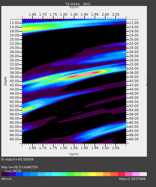
| Estimated Moho Depth: |
36.5 km |
| Estimated Crust Vp/Vs: |
1.90 |
| Assumed Crust Vp: |
6.38 km/s |
| Estimated Crust Vs: |
3.354 km/s |
| Estimated Crust Poisson's Ratio: |
0.31 |
|
| Radial Match: |
95.58809 % |
| Radial Bump: |
377 |
| Transverse Match: |
69.52757 % |
| Transverse Bump: |
400 |
| SOD ConfigId: |
478790 |
| Insert Time: |
2013-02-23 01:01:25.892 +0000 |
| GWidth: |
2.5 |
| Max Bumps: |
400 |
| Tol: |
0.001 |
|
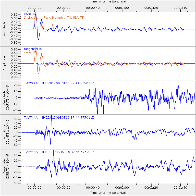
Signal To Noise
| Channel | StoN | STA | LTA |
| TA:W44A: :BHZ:20120930T16:37:44.575011Z | 19.805838 | 7.1912145E-6 | 3.630856E-7 |
| TA:W44A: :BHN:20120930T16:37:44.575011Z | 4.7587843 | 2.9825783E-6 | 6.267521E-7 |
| TA:W44A: :BHE:20120930T16:37:44.575011Z | 3.0459056 | 1.1911186E-6 | 3.9105566E-7 |
| Arrivals |
| Ps | 5.5 SECOND |
| PpPs | 16 SECOND |
| PsPs/PpSs | 21 SECOND |


