You are here: Home > Network List > TA - USArray Transportable Network (new EarthScope stations) Stations List
> Station J39A Decorah, IA, USA > Earthquake Result Viewer
J39A Decorah, IA, USA - Earthquake Result Viewer
| Earthquake location: |
Colombia |
| Earthquake latitude/longitude: |
1.9/-76.4 |
| Earthquake time(UTC): |
2012/09/30 (274) 16:31:35 GMT |
| Earthquake Depth: |
170 km |
| Earthquake Magnitude: |
7.0 MB, 7.3 MW, 7.2 MW |
| Earthquake Catalog/Contributor: |
WHDF/NEIC |
|
| Network: |
TA USArray Transportable Network (new EarthScope stations) |
| Station: |
J39A Decorah, IA, USA |
| Lat/Lon: |
43.34 N/91.71 W |
| Elevation: |
350 m |
|
| Distance: |
43.4 deg |
| Az: |
343.692 deg |
| Baz: |
157.379 deg |
| Ray Param: |
0.07190641 |
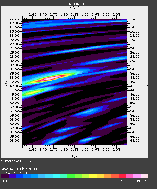
| Estimated Moho Depth: |
38.0 km |
| Estimated Crust Vp/Vs: |
1.74 |
| Assumed Crust Vp: |
6.53 km/s |
| Estimated Crust Vs: |
3.759 km/s |
| Estimated Crust Poisson's Ratio: |
0.25 |
|
| Radial Match: |
96.38373 % |
| Radial Bump: |
400 |
| Transverse Match: |
85.984375 % |
| Transverse Bump: |
400 |
| SOD ConfigId: |
478790 |
| Insert Time: |
2013-02-23 01:02:57.461 +0000 |
| GWidth: |
2.5 |
| Max Bumps: |
400 |
| Tol: |
0.001 |
|

Signal To Noise
| Channel | StoN | STA | LTA |
| TA:J39A: :BHZ:20120930T16:38:51.499999Z | 99.05499 | 1.4327133E-5 | 1.4463816E-7 |
| TA:J39A: :BHN:20120930T16:38:51.499999Z | 86.273636 | 7.490898E-6 | 8.682719E-8 |
| TA:J39A: :BHE:20120930T16:38:51.499999Z | 12.832442 | 1.6229973E-6 | 1.264761E-7 |
| Arrivals |
| Ps | 4.6 SECOND |
| PpPs | 15 SECOND |
| PsPs/PpSs | 19 SECOND |


