You are here: Home > Network List > TA - USArray Transportable Network (new EarthScope stations) Stations List
> Station X42A Stuttgart, AR, USA > Earthquake Result Viewer
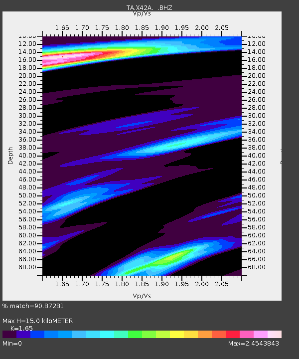
X42A Stuttgart, AR, USA - Earthquake Result Viewer
| Earthquake location: |
Colombia |
| Earthquake latitude/longitude: |
1.9/-76.4 |
| Earthquake time(UTC): |
2012/09/30 (274) 16:31:35 GMT |
| Earthquake Depth: |
170 km |
| Earthquake Magnitude: |
7.0 MB, 7.3 MW, 7.2 MW |
| Earthquake Catalog/Contributor: |
WHDF/NEIC |
|
| Network: |
TA USArray Transportable Network (new EarthScope stations) |
| Station: |
X42A Stuttgart, AR, USA |
| Lat/Lon: |
34.55 N/91.63 W |
| Elevation: |
62 m |
|
| Distance: |
35.4 deg |
| Az: |
337.993 deg |
| Baz: |
153.016 deg |
| Ray Param: |
0.07661182 |
| Estimated Moho Depth: |
15.0 km |
| Estimated Crust Vp/Vs: |
1.65 |
| Assumed Crust Vp: |
6.273 km/s |
| Estimated Crust Vs: |
3.802 km/s |
| Estimated Crust Poisson's Ratio: |
0.21 |
|
| Radial Match: |
90.87281 % |
| Radial Bump: |
400 |
| Transverse Match: |
80.97412 % |
| Transverse Bump: |
400 |
| SOD ConfigId: |
478790 |
| Insert Time: |
2013-02-23 01:04:33.182 +0000 |
| GWidth: |
2.5 |
| Max Bumps: |
400 |
| Tol: |
0.001 |
|

Signal To Noise
| Channel | StoN | STA | LTA |
| TA:X42A: :BHZ:20120930T16:37:45.499999Z | 27.608734 | 6.3792786E-6 | 2.3106016E-7 |
| TA:X42A: :BHN:20120930T16:37:45.499999Z | 7.0826716 | 3.0647911E-6 | 4.3271683E-7 |
| TA:X42A: :BHE:20120930T16:37:45.499999Z | 4.313409 | 1.7751912E-6 | 4.115518E-7 |
| Arrivals |
| Ps | 1.7 SECOND |
| PpPs | 5.9 SECOND |
| PsPs/PpSs | 7.5 SECOND |


