You are here: Home > Network List > TA - USArray Transportable Network (new EarthScope stations) Stations List
> Station P44A Sand Creek, Windsor, IL, USA > Earthquake Result Viewer
P44A Sand Creek, Windsor, IL, USA - Earthquake Result Viewer
| Earthquake location: |
Colombia |
| Earthquake latitude/longitude: |
1.9/-76.4 |
| Earthquake time(UTC): |
2012/09/30 (274) 16:31:35 GMT |
| Earthquake Depth: |
170 km |
| Earthquake Magnitude: |
7.0 MB, 7.3 MW, 7.2 MW |
| Earthquake Catalog/Contributor: |
WHDF/NEIC |
|
| Network: |
TA USArray Transportable Network (new EarthScope stations) |
| Station: |
P44A Sand Creek, Windsor, IL, USA |
| Lat/Lon: |
39.47 N/88.62 W |
| Elevation: |
195 m |
|
| Distance: |
39.0 deg |
| Az: |
344.86 deg |
| Baz: |
160.292 deg |
| Ray Param: |
0.074605376 |
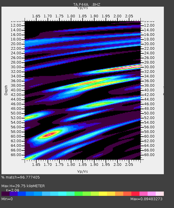
| Estimated Moho Depth: |
29.75 km |
| Estimated Crust Vp/Vs: |
2.06 |
| Assumed Crust Vp: |
6.444 km/s |
| Estimated Crust Vs: |
3.128 km/s |
| Estimated Crust Poisson's Ratio: |
0.35 |
|
| Radial Match: |
96.777405 % |
| Radial Bump: |
400 |
| Transverse Match: |
79.38896 % |
| Transverse Bump: |
400 |
| SOD ConfigId: |
478790 |
| Insert Time: |
2013-02-23 01:05:27.353 +0000 |
| GWidth: |
2.5 |
| Max Bumps: |
400 |
| Tol: |
0.001 |
|
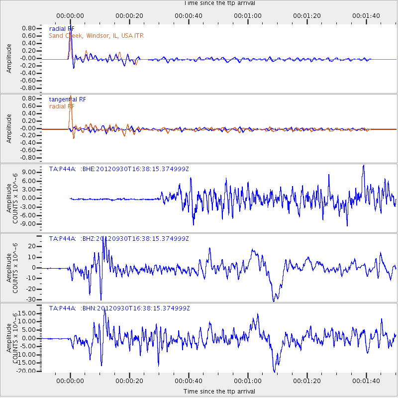
Signal To Noise
| Channel | StoN | STA | LTA |
| TA:P44A: :BHZ:20120930T16:38:15.374999Z | 21.823385 | 4.3096275E-6 | 1.9747749E-7 |
| TA:P44A: :BHN:20120930T16:38:15.374999Z | 14.564567 | 2.277851E-6 | 1.5639678E-7 |
| TA:P44A: :BHE:20120930T16:38:15.374999Z | 8.181897 | 1.0065945E-6 | 1.2302702E-7 |
| Arrivals |
| Ps | 5.2 SECOND |
| PpPs | 13 SECOND |
| PsPs/PpSs | 18 SECOND |


