You are here: Home > Network List > TA - USArray Transportable Network (new EarthScope stations) Stations List
> Station U45A Rockin P Farm, Martin, TN, USA > Earthquake Result Viewer
U45A Rockin P Farm, Martin, TN, USA - Earthquake Result Viewer

| Earthquake location: |
Colombia |
| Earthquake latitude/longitude: |
1.9/-76.4 |
| Earthquake time(UTC): |
2012/09/30 (274) 16:31:35 GMT |
| Earthquake Depth: |
170 km |
| Earthquake Magnitude: |
7.0 MB, 7.3 MW, 7.2 MW |
| Earthquake Catalog/Contributor: |
WHDF/NEIC |
|
| Network: |
TA USArray Transportable Network (new EarthScope stations) |
| Station: |
U45A Rockin P Farm, Martin, TN, USA |
| Lat/Lon: |
36.35 N/88.76 W |
| Elevation: |
144 m |
|
| Distance: |
36.1 deg |
| Az: |
342.895 deg |
| Baz: |
158.647 deg |
| Ray Param: |
0.07624761 |
| Estimated Moho Depth: |
10.0 km |
| Estimated Crust Vp/Vs: |
1.62 |
| Assumed Crust Vp: |
6.444 km/s |
| Estimated Crust Vs: |
3.99 km/s |
| Estimated Crust Poisson's Ratio: |
0.19 |
|
| Radial Match: |
93.50247 % |
| Radial Bump: |
400 |
| Transverse Match: |
74.472046 % |
| Transverse Bump: |
400 |
| SOD ConfigId: |
478790 |
| Insert Time: |
2013-02-23 01:05:32.246 +0000 |
| GWidth: |
2.5 |
| Max Bumps: |
400 |
| Tol: |
0.001 |
|
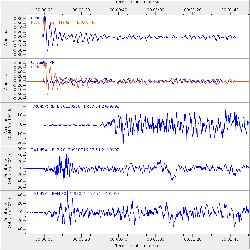
Signal To Noise
| Channel | StoN | STA | LTA |
| TA:U45A: :BHZ:20120930T16:37:51.249999Z | 24.326117 | 4.5587753E-6 | 1.874025E-7 |
| TA:U45A: :BHN:20120930T16:37:51.249999Z | 10.243574 | 3.6592833E-6 | 3.572272E-7 |
| TA:U45A: :BHE:20120930T16:37:51.249999Z | 6.1188703 | 1.5452304E-6 | 2.5253524E-7 |
| Arrivals |
| Ps | 1.0 SECOND |
| PpPs | 3.7 SECOND |
| PsPs/PpSs | 4.8 SECOND |


