You are here: Home > Network List > TA - USArray Transportable Network (new EarthScope stations) Stations List
> Station I39A Houston, MN, USA > Earthquake Result Viewer
I39A Houston, MN, USA - Earthquake Result Viewer

| Earthquake location: |
Colombia |
| Earthquake latitude/longitude: |
1.9/-76.4 |
| Earthquake time(UTC): |
2012/09/30 (274) 16:31:35 GMT |
| Earthquake Depth: |
170 km |
| Earthquake Magnitude: |
7.0 MB, 7.3 MW, 7.2 MW |
| Earthquake Catalog/Contributor: |
WHDF/NEIC |
|
| Network: |
TA USArray Transportable Network (new EarthScope stations) |
| Station: |
I39A Houston, MN, USA |
| Lat/Lon: |
43.85 N/91.52 W |
| Elevation: |
393 m |
|
| Distance: |
43.9 deg |
| Az: |
344.156 deg |
| Baz: |
157.841 deg |
| Ray Param: |
0.071645804 |
| Estimated Moho Depth: |
35.25 km |
| Estimated Crust Vp/Vs: |
1.85 |
| Assumed Crust Vp: |
6.53 km/s |
| Estimated Crust Vs: |
3.53 km/s |
| Estimated Crust Poisson's Ratio: |
0.29 |
|
| Radial Match: |
96.51143 % |
| Radial Bump: |
400 |
| Transverse Match: |
85.39772 % |
| Transverse Bump: |
400 |
| SOD ConfigId: |
478790 |
| Insert Time: |
2013-02-23 01:05:39.418 +0000 |
| GWidth: |
2.5 |
| Max Bumps: |
400 |
| Tol: |
0.001 |
|
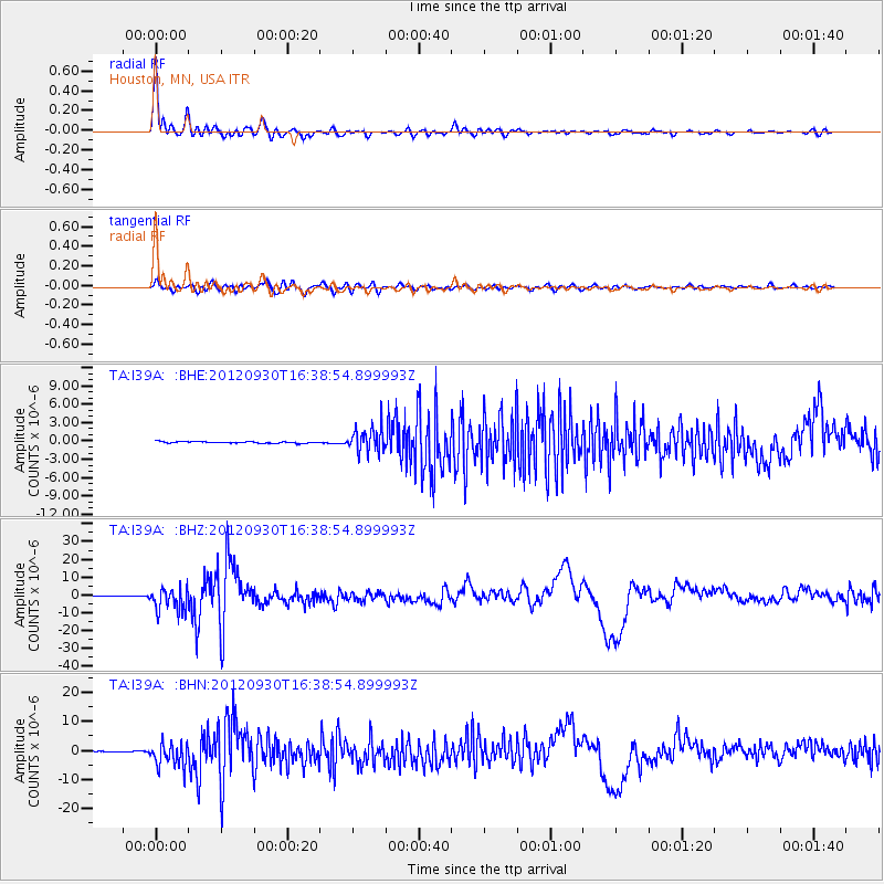
Signal To Noise
| Channel | StoN | STA | LTA |
| TA:I39A: :BHZ:20120930T16:38:54.899993Z | 37.340458 | 6.6360108E-6 | 1.7771637E-7 |
| TA:I39A: :BHN:20120930T16:38:54.899993Z | 31.223743 | 4.1604567E-6 | 1.3324657E-7 |
| TA:I39A: :BHE:20120930T16:38:54.899993Z | 15.242173 | 2.0227233E-6 | 1.3270571E-7 |
| Arrivals |
| Ps | 4.9 SECOND |
| PpPs | 14 SECOND |
| PsPs/PpSs | 19 SECOND |


